IMAGES TAKEN NEAR TO
Northwick Road, BRISTOL, BS35 4HE
Introduction
This page details the photographs taken nearby to Northwick Road, BS35 4HE by members of the Geograph project.
The Geograph project started in 2005 with the aim of publishing, organising and preserving representative images for every square kilometre of Great Britain, Ireland and the Isle of Man.

There are currently over 7.5m images from over14,400 individuals and you can help contribute to the project by visiting https://www.geograph.org.uk
Image Map (Loading...)


Getting Data...Please wait
Leaflet Map data © OpenStreetMap
Images are licensed for reuse under creativecommons.org/licenses/by-sa/2.0
Notes
- Clicking on the map will re-center to the selected point.
- The higher the marker number, the further away the image location is from the centre of the postcode.
Image Listing (65 Images Found)
Images are licensed for reuse under creativecommons.org/licenses/by-sa/2.0
Image
Details
Distance
1
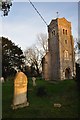
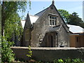
Northwick : Northwick Tower
Church tower. 1842-3 by John Hicks. Rubble with stone dressings. Square plan, neo-Romanesque style. http://list.english-heritage.org.uk/resultsingle.aspx?uid=1312454&searchtype=mapsearch
Image: © Lewis Clarke
Taken: 8 Mar 2014
0.00 miles
2
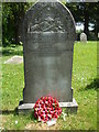
A family fallen
A war memorial to two men of the same name, presumably brothers, who lost their lives in the Great War.
Image: © Neil Owen
Taken: 20 May 2020
0.00 miles
3
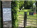
A long gone council
The sign refers to the North Avon District Council, which was part of the former Avon County Council. Both disappeared under the reorganisation of 1996, but there does appear to be a bona fide footpath through the former churchyard.
Image: © Neil Owen
Taken: 20 May 2020
0.01 miles
4
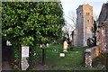
Northwick : Northwick Tower
The entrance to Northwick Tower grounds and the footpath which heads through it.
Image: © Lewis Clarke
Taken: 8 Mar 2014
0.01 miles
5
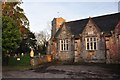
Tower, St Thomas' Church, Northwick
School is also in shot.
Image: © JThomas
Taken: 11 May 2013
0.01 miles
6
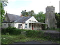
Northwick : Sandfords Charity School
School. Dated 1842 on name plaque, with later alterations. Coursed rubble, stone dressings, slate roof coated with bitumen, raised coped verges with kneelers and ball finials. http://list.english-heritage.org.uk/resultsingle.aspx?uid=1128953&searchtype=mapsearch
Image: © Lewis Clarke
Taken: 8 Mar 2014
0.01 miles
7
Northwick school
Originally Sandford's Charity School (1842), this building functioned as the village school until 2007.
Image: © Neil Owen
Taken: 20 May 2020
0.01 miles
8
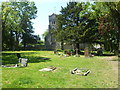
The tombs and the tower remain
St Thomas's church dated from around the 1600s and substantially rebuilt in 1842. However, then structure became more unsteady and serious problems were declared in 1962. The church was declared redundant in 1971 and the main body demolished. The local parish took over responsibility in the 1980s.
Image: © Neil Owen
Taken: 20 May 2020
0.01 miles
9
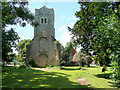
St. Thomas' church, Northwick
The church was built in the 1840's but most was subsequently demolished because of problems with subsidence. Only the tower remains.
Image: © Jonathan Billinger
Taken: 3 Jul 2009
0.01 miles
10
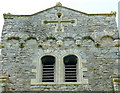
St. Thomas' church, Northwick - tower detail
Showing the grotesques on the Norman-influenced tower.
Image: © Jonathan Billinger
Taken: 3 Jul 2009
0.01 miles