IMAGES TAKEN NEAR TO
The Common, BRISTOL, BS35 4DQ
Introduction
This page details the photographs taken nearby to The Common, BS35 4DQ by members of the Geograph project.
The Geograph project started in 2005 with the aim of publishing, organising and preserving representative images for every square kilometre of Great Britain, Ireland and the Isle of Man.

There are currently over 7.5m images from over14,400 individuals and you can help contribute to the project by visiting https://www.geograph.org.uk
Image Map (Loading...)


Getting Data...Please wait
Leaflet Map data © OpenStreetMap
Images are licensed for reuse under creativecommons.org/licenses/by-sa/2.0
Notes
- Clicking on the map will re-center to the selected point.
- The higher the marker number, the further away the image location is from the centre of the postcode.
Image Listing (12 Images Found)
Images are licensed for reuse under creativecommons.org/licenses/by-sa/2.0
Image
Details
Distance
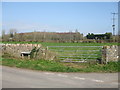
1
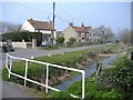
Mill Farm, Olveston Common
The watercourse in the foreground, is Mill Rhine.
Image: © Roger Cornfoot
Taken: 28 Mar 2007
0.02 miles
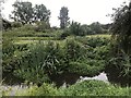
2
A verdent rhine with prolific watercress and moorhen
Image: © Dr Duncan Pepper
Taken: 18 Jun 2013
0.04 miles
3
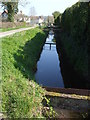
Little bridges over the rhyne
The land around Olveston is crossed regularly with drainage rhynes; the homes backing on to this one have little steel bridges for access.
Image: © Neil Owen
Taken: 28 Mar 2019
0.07 miles
4
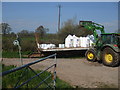
Work at the end of The Common
Some heavy lifting and distribution at the end of the road; two footpaths and a bridleway take over from here.
Image: © Neil Owen
Taken: 28 Mar 2019
0.08 miles
5
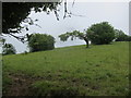
The Northern slopes of St Catherines Hill
Image: © Dr Duncan Pepper
Taken: 18 Jun 2013
0.09 miles
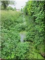
6
One of many rhines on Olveston Common
Rhine being the local name for a drainage ditch.
Image: © Dr Duncan Pepper
Taken: 18 Jun 2013
0.14 miles
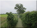
7
Catherine Hill
A small inclined patch just outside the rural houses of Olveston.
Image: © Neil Owen
Taken: 28 Mar 2019
0.14 miles
8
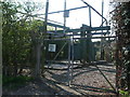
Pumping station in Olveston
Almost surrounded by lots of drainage rhynes, the village needs some heavy plant to keep the levels under control.
Image: © Neil Owen
Taken: 28 Mar 2019
0.17 miles
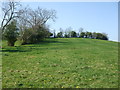
9
The Common, Olveston
The land to the west of the village is named The Common, although there are plenty of drainage rhynes to negotiate.
Image: © Neil Owen
Taken: 28 Mar 2019
0.18 miles
10
Drain at junction of Ley Lane and Church Hill
Image: © don cload
Taken: 15 Aug 2020
0.18 miles