IMAGES TAKEN NEAR TO
The Street, BRISTOL, BS35 4DP
Introduction
This page details the photographs taken nearby to The Street, BS35 4DP by members of the Geograph project.
The Geograph project started in 2005 with the aim of publishing, organising and preserving representative images for every square kilometre of Great Britain, Ireland and the Isle of Man.

There are currently over 7.5m images from over14,400 individuals and you can help contribute to the project by visiting https://www.geograph.org.uk
Image Map (Loading...)


Getting Data...Please wait
Leaflet Map data © OpenStreetMap
Images are licensed for reuse under creativecommons.org/licenses/by-sa/2.0
Notes
- Clicking on the map will re-center to the selected point.
- The higher the marker number, the further away the image location is from the centre of the postcode.
Image Listing (53 Images Found)
Images are licensed for reuse under creativecommons.org/licenses/by-sa/2.0
Image
Details
Distance
1
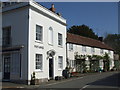
The old Post Office on Vicarage Lane
Closed around 1900, this fine building carries on as a private residence. See Image] for the western aspect. Grade II listed from 1952, no less.
Image: © Neil Owen
Taken: 28 Mar 2019
0.01 miles
2
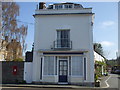
The old Post Office, Olveston
This fine building in the centre of the village was once the Post Office before the duties were transferred to another site around the turn of the 1900s. See Image] for a look at the southern aspect.
Image: © Neil Owen
Taken: 28 Mar 2019
0.01 miles
3
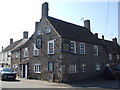
The White Hart, Olveston
The sixteenth century inn occupies a prime spot in the village: opposite the church and right on the main crossroads.
Image: © Neil Owen
Taken: 28 Mar 2019
0.02 miles
4
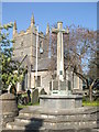
Olveston's war memorial
This cross, founded by grateful parishioners, bears the names of a number of village men that were claimed in the wars, including Korea. Interestingly, it also has a plaque that marks the 50th Anniversary Celebrations of VE/VJ Days. For greater information, the memorial now has a modern aspect - see Image
Image: © Neil Owen
Taken: 28 Mar 2019
0.02 miles
5
The modern way of interpreting history
Close to the war memorial cross is this little piece of interest. For those wanting to look further into the details there is a handy help - providing you have the right piece of modern communications hardware. See Image] for an analogue look at the monument.
Image: © Neil Owen
Taken: 28 Mar 2019
0.03 miles
6
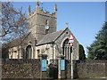
St Mary the Virgin, Olveston
The village's prime place of worship since Norman times, the church has an interesting and continuing history. A benchmark can be found on the left of the east window seen here - see Image
Image: © Neil Owen
Taken: 28 Mar 2019
0.03 miles
7
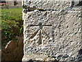
Bolt benchmark on St Mary's, Olveston
A classic First Geodetic Levelling benchmark on a village church. See https://www.bench-marks.org.uk/bm30655 for the entry in the Benchmark Database and Image] for a wider view. The mark is on the left side of the east aspect.
Image: © Neil Owen
Taken: 28 Mar 2019
0.03 miles
8
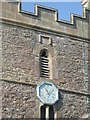
In quick time
The church tower of St Mary's was badly damaged by lightning in 1605. The date stone appears to bear the year 1606 - showing how quickly it was rebuilt.
Image: © Neil Owen
Taken: 28 Mar 2019
0.03 miles
9
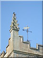
Top of St Mary's
The fine tower and pinnacles of the church - along with a shining weathervane. The tower was hit by lightning in 1605 - just after the Gunpowder Plot. A letter written by the schoolmaster to the King inferred the wrath of God and implying the plot of recent weeks; the result was that the tower was rebuilt swiftly.
Image: © Neil Owen
Taken: 28 Mar 2019
0.04 miles
10
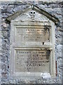
An ancient sign of death
This tablet in St Mary's church is dated 1662, following the rebuilding of the tower a few decades earlier. The stark skull was quite a common feature of memorial stones and tablets of that era.
Image: © Neil Owen
Taken: 28 Mar 2019
0.04 miles