IMAGES TAKEN NEAR TO
Passage Road, BRISTOL, BS35 4BG
Introduction
This page details the photographs taken nearby to Passage Road, BS35 4BG by members of the Geograph project.
The Geograph project started in 2005 with the aim of publishing, organising and preserving representative images for every square kilometre of Great Britain, Ireland and the Isle of Man.

There are currently over 7.5m images from over14,400 individuals and you can help contribute to the project by visiting https://www.geograph.org.uk
Image Map
Images are licensed for reuse under creativecommons.org/licenses/by-sa/2.0
Notes
- Clicking on the map will re-center to the selected point.
- The higher the marker number, the further away the image location is from the centre of the postcode.
Image Listing (96 Images Found)
Images are licensed for reuse under creativecommons.org/licenses/by-sa/2.0
Image
Details
Distance
1
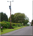
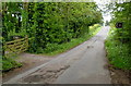
Short post, tall pole alongside Passage Road, Aust
Looking WSW along Passage Road, past a short speed limit post, towards a bend ahead.
Image: © Jaggery
Taken: 20 May 2012
0.03 miles
2
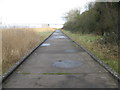
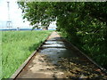
Access road at Aust Cliff
Providing firm access through the marsh to the pylons where the national grid crosses the Severn Estuary.
Image: © Dr Duncan Pepper
Taken: 24 Jan 2009
0.05 miles
3
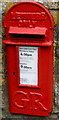
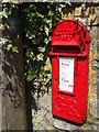
King George V postbox, Old Passage, Aust
Located here http://www.geograph.org.uk/photo/4245691. The latest collection times (late May 2012)
are shown on the notice, which states that a later collection is
made from the postbox at Bristol Mail Centre in Gloucester Road North.
Image: © Jaggery
Taken: 20 May 2012
0.06 miles
4
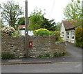
Old Passage postbox in a wall, Aust
Viewed across Passage Road. The letters GR on the postbox http://www.geograph.org.uk/photo/4245683 date it to the reign of King George V.
Image: © Jaggery
Taken: 20 May 2012
0.06 miles
5
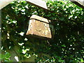
Georgian postbox on Passage Road
Also on the pole is a Two Rivers walking path marker, although it's in the shadows.
Image: © Neil Owen
Taken: 20 May 2020
0.06 miles
6
Vineyard sign, Passage Road, Aust
The brown sign points left across Passage Road to St Augustine's Vineyard. http://www.geograph.org.uk/photo/4245652
Image: © Jaggery
Taken: 20 May 2012
0.06 miles
7
Aust Ferry (Looking down the National Grid passage)
Image: © Nick Mutton 01329 000000
Taken: 16 Jun 2007
0.06 miles
8
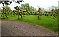
St Augustine's Vineyard, Aust
On the south side of Passage Road, viewed in late May 2012.
Image: © Jaggery
Taken: 20 May 2012
0.07 miles
9
Aust Ferry (Gents Toilet block) - Water flush cistern
You can still see the metal water cistern here for flushing the urinals.
Image: © Nick Mutton 01329 000000
Taken: 16 Jun 2007
0.08 miles
10
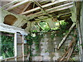
Aust Ferry (Inside the shop & refreshment area)
A sad sight here.
Image: © Nick Mutton 01329 000000
Taken: 16 Jun 2007
0.08 miles