IMAGES TAKEN NEAR TO
Bristol Road, BRISTOL, BS35 3XL
Introduction
This page details the photographs taken nearby to Bristol Road, BS35 3XL by members of the Geograph project.
The Geograph project started in 2005 with the aim of publishing, organising and preserving representative images for every square kilometre of Great Britain, Ireland and the Isle of Man.

There are currently over 7.5m images from over14,400 individuals and you can help contribute to the project by visiting https://www.geograph.org.uk
Image Map (Loading...)


Getting Data...Please wait
Leaflet Map data © OpenStreetMap
Images are licensed for reuse under creativecommons.org/licenses/by-sa/2.0
Notes
- Clicking on the map will re-center to the selected point.
- The higher the marker number, the further away the image location is from the centre of the postcode.
Image Listing (4 Images Found)
Images are licensed for reuse under creativecommons.org/licenses/by-sa/2.0
Image
Details
Distance

2
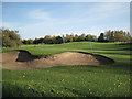
Par 3 course, Thornbury Golf Centre
Just visible above the trees, centre, is the ballstop fence to the driving range.
Image: © Robin Stott
Taken: 27 Oct 2010
0.16 miles
3
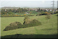
Scrub on a hillside
A footpath leads from Thornbury's Mundy playing fields, centre, up a hillside. The route is followed by the Jubilee Way http://www.ldwa.org.uk/ldp/members/show_path.php?path_name=Jubilee+Way+(South+Gloucestershire) On the right is a horse chestnut, perhaps a commemorative tree, standing behind a concrete base from which a bench has been forcibly removed. On the left skyline are the woods above Hill. Faint grey in the distance is the edge of the Cotswolds.
Image: © Robin Stott
Taken: 27 Oct 2010
0.18 miles
4
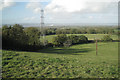
Hillside southwest of Thornbury
A footpath from the Mundy playing fields leads up on to a north-facing slope with views to Oldbury, the river Severn and the Forest of Dean. Lower Marlwood Farm is out of shot, right, in the next square. This route is followed by the Jubilee Way http://www.ldwa.org.uk/ldp/members/show_path.php?path_name=Jubilee+Way+(South+Gloucestershire)
Image: © Robin Stott
Taken: 27 Oct 2010
0.24 miles