IMAGES TAKEN NEAR TO
Old Gloucester Road, BRISTOL, BS35 3UF
Introduction
This page details the photographs taken nearby to Old Gloucester Road, BS35 3UF by members of the Geograph project.
The Geograph project started in 2005 with the aim of publishing, organising and preserving representative images for every square kilometre of Great Britain, Ireland and the Isle of Man.

There are currently over 7.5m images from over14,400 individuals and you can help contribute to the project by visiting https://www.geograph.org.uk
Image Map (Loading...)


Getting Data...Please wait
Leaflet Map data © OpenStreetMap
Images are licensed for reuse under creativecommons.org/licenses/by-sa/2.0
Notes
- Clicking on the map will re-center to the selected point.
- The higher the marker number, the further away the image location is from the centre of the postcode.
Image Listing (7 Images Found)
Images are licensed for reuse under creativecommons.org/licenses/by-sa/2.0
Image
Details
Distance
2
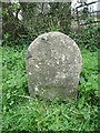
Old Milestone by the B4061, Gloucester Road, Morton Farm
Stone post (probably with plate lost) by the B4061, in parish of THORNBURY (SOUTH GLOUCESTERSHIRE District), Gloucester Road, 100m East of Morton Farm, next to Milestone Cottage on grass verge, on South side of road. (Bristol incised iron plate), erected by the Bristol Turnpike Trust in the 19th century.
Inscription once read:-
(Bristol 13)
(Thornbury 2)
(Gloucester 21)
The inscription was probably defaced as a security measure in WWII.
Milestone Society National ID: GL_BRGLA13.
Image: © Milestone Society
Taken: 19 Mar 2017
0.07 miles
3
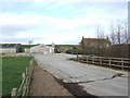
Modern houses on the Gloucester Road
These modern houses are located in the otherwise largely rural landscape adjacent to the Gloucester Road between Thornbury and junction 14 of the M5.
Image: © Ruth Riddle
Taken: 7 Dec 2011
0.16 miles
4
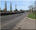
West along Gloucester Road, Thornbury
Viewed from the entrance road to the Springfield Supplies and Projects site.
Image: © Jaggery
Taken: 19 Feb 2023
0.19 miles
5
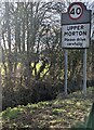
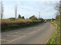
UPPER MORTON - Please drive carefully
Alongside Gloucester Road in South Gloucestershire.
The National Speed Limit drops to 40mph.
Image: © Jaggery
Taken: 19 Feb 2023
0.19 miles
6
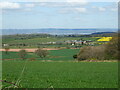
North from Horseshoe Hill
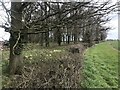
Some agricultural lands across to the Bristol Channel. It's time for the oilseed rape fields to explode into their distinct colour.
Image: © Neil Owen
Taken: 15 Apr 2021
0.23 miles