IMAGES TAKEN NEAR TO
Crossways Lane, BRISTOL, BS35 3UE
Introduction
This page details the photographs taken nearby to Crossways Lane, BS35 3UE by members of the Geograph project.
The Geograph project started in 2005 with the aim of publishing, organising and preserving representative images for every square kilometre of Great Britain, Ireland and the Isle of Man.

There are currently over 7.5m images from over14,400 individuals and you can help contribute to the project by visiting https://www.geograph.org.uk
Image Map (Loading...)


Getting Data...Please wait
Leaflet Map data © OpenStreetMap
Images are licensed for reuse under creativecommons.org/licenses/by-sa/2.0
Notes
- Clicking on the map will re-center to the selected point.
- The higher the marker number, the further away the image location is from the centre of the postcode.
Image Listing (10 Images Found)
Images are licensed for reuse under creativecommons.org/licenses/by-sa/2.0
Image
Details
Distance
1
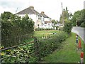
Semi-detached houses, Crossways Lane
Crossways Lane is a length of Knapp Road renamed. The vegetable plot in the foreground is but a small part of two long allotments running back from the road.
Image: © Robin Stott
Taken: 18 Sep 2010
0.04 miles
2
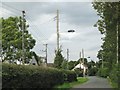
Crossways Lane by Knapp Farm
Sprouting here and there along these lanes are classic examples of 'wirescape' – the term used by the late Gordon Cullen. Crossways Lane is a length of Knapp Road renamed.
Image: © Robin Stott
Taken: 18 Sep 2010
0.05 miles
3
House at the junction of Crossways Lane and Clay Lane
One of many houses on the pleasant lanes that lie to the east of Thornbury outside of the intensive development area bounded by Morton Way.
Image: © Ruth Riddle
Taken: 11 Feb 2012
0.10 miles
4
Paddocks, Crossways Lane
Crossways Road is a length of Knapp Road renamed.
Image: © Robin Stott
Taken: 18 Sep 2010
0.12 miles
5
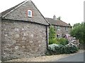
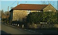
Foxhole Cottage, Crossways Lane
The older houses northeast of Thornbury are built of mixed sandstones. Crossways Lane is a length of Knapp Road renamed.
Image: © Robin Stott
Taken: 18 Sep 2010
0.12 miles
6
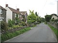
Houses, Crossways Lane
Crossways Lane is a length of Knapp Road renamed.
Image: © Robin Stott
Taken: 18 Sep 2010
0.19 miles
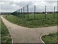
7
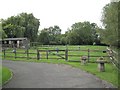
Open space
Land provided by the new housing development
Image: © don cload
Taken: 22 Mar 2021
0.19 miles
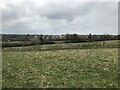
9
Harrowed fields near Knapp Farm
The viewpoint is Crossways Lane just northeast of Knapp Farm. Crossways Lane is a length of Knapp Road renamed. The grey hills in the distance are across the river Severn.
Image: © Robin Stott
Taken: 18 Sep 2010
0.23 miles
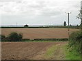
10

Amalgamated fields behind Crossways Chapel
Beyond the pylon is Buckover Image
Image: © Robin Stott
Taken: 18 Sep 2010
0.24 miles