IMAGES TAKEN NEAR TO
Gloucester Road, BRISTOL, BS35 3TR
Introduction
This page details the photographs taken nearby to Gloucester Road, BS35 3TR by members of the Geograph project.
The Geograph project started in 2005 with the aim of publishing, organising and preserving representative images for every square kilometre of Great Britain, Ireland and the Isle of Man.

There are currently over 7.5m images from over14,400 individuals and you can help contribute to the project by visiting https://www.geograph.org.uk
Image Map (Loading...)


Getting Data...Please wait
Leaflet Map data © OpenStreetMap
Images are licensed for reuse under creativecommons.org/licenses/by-sa/2.0
Notes
- Clicking on the map will re-center to the selected point.
- The higher the marker number, the further away the image location is from the centre of the postcode.
Image Listing (13 Images Found)
Images are licensed for reuse under creativecommons.org/licenses/by-sa/2.0
Image
Details
Distance
1
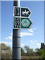
The Jubilee Way on Abbey Lane
The sticker is of the Ramblers' Association 50th anniversary in 1985. The Jubilee Way here is a 26km (16 mile) long route which links Aust, at the south side of the Severn Bridge, with Old Sodbury at the base of the Cotswold Hills.
Image: © Neil Owen
Taken: 15 Apr 2021
0.04 miles
2
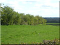
Little Abbey fort by Abbey Lane
This is the west edge of the univalate fort site near Tytherington. A modern hedgeline marks fairly closely where the earthworks' meagre traces are.
Image: © Neil Owen
Taken: 15 Apr 2021
0.05 miles
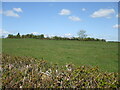
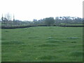
4

Ripples under the daisies
The site of Little Abbey fort has been cultivated for many years and the old earthworks have been greatly reduced. The Iron Age fort had, it's thought, some fairly wide embankments originally, although only one set of them. Today they are merely ripples in the field level.
Image: © Neil Owen
Taken: 15 Apr 2021
0.13 miles
5
Little Abbey fort
Although termed a fort, the simple and fairly featureless area of the earthworks is less likely to be a military site. Indeed, what finds have come to light are more Roman than Iron Age. It's worth noting there is a larger hillfort about 1Km to the southeast (The Roman Camp at Tytherington), although it's been heavily quarried.
Image: © Neil Owen
Taken: 15 Apr 2021
0.13 miles
6
Little Abbey Fort
The main A38 has crashed straight through a small but interesting earthwork just by Tytherington. It is a univalate fort, thought to be Iron Age but with some Roman finds. Here the land shows some elevation, much mellowed by ploughing.
Image: © Neil Owen
Taken: 15 Apr 2021
0.15 miles
7
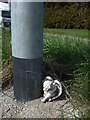
A sad angel by a lamppost
A curious little effigy to find at the foot of a lamppost along a rural part of the A38. But a little examination of the scene reveals a plaque on a wall nearby: it is in memoriam to a truck driver who lost control of his vehicle and crashed fatally in October, 2019.
Image: © Neil Owen
Taken: 15 Apr 2021
0.19 miles
8
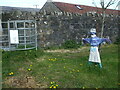
It's actually a nurse
This odd 'scarecrow' is a medical worker, and thus is a tribute to the N.H.S. workers in the Covid period.
Image: © Neil Owen
Taken: 15 Apr 2021
0.21 miles
9
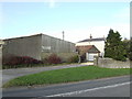
Grovesend House
Offices of consultant engineers, just off the A38 to the south of Thornbury.
Image: © Jonathan Billinger
Taken: 15 Jan 2007
0.24 miles
10
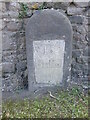
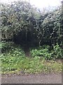
Milestone outside Grovesend Farm
A somewhat weathered and tarnished milestone on the A38. Fortunately, the plate is still there and readable. See Image] for a wider view and Image] for a rivet benchmark on the top.
Image: © Neil Owen
Taken: 15 Apr 2021
0.24 miles