IMAGES TAKEN NEAR TO
Gloucester Road, BRISTOL, BS35 3QJ
Introduction
This page details the photographs taken nearby to Gloucester Road, BS35 3QJ by members of the Geograph project.
The Geograph project started in 2005 with the aim of publishing, organising and preserving representative images for every square kilometre of Great Britain, Ireland and the Isle of Man.

There are currently over 7.5m images from over14,400 individuals and you can help contribute to the project by visiting https://www.geograph.org.uk
Image Map (Loading...)


Getting Data...Please wait
Leaflet Map data © OpenStreetMap
Images are licensed for reuse under creativecommons.org/licenses/by-sa/2.0
Notes
- Clicking on the map will re-center to the selected point.
- The higher the marker number, the further away the image location is from the centre of the postcode.
Image Listing (11 Images Found)
Images are licensed for reuse under creativecommons.org/licenses/by-sa/2.0
Image
Details
Distance
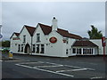
1
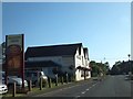
The Masons Arms on the A38
Surely there should be an apostrophe in the name?
Image: © David Smith
Taken: 28 Jul 2012
0.01 miles
3
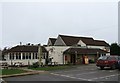
The Masons Arms
A public house on the main A38 Gloucester Road in Rudgeway.
Image: © Ruth Riddle
Taken: 31 Dec 2011
0.01 miles
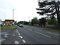
7
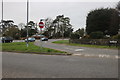
Church Road at the junction of Gloucester Road
Image: © David Howard
Taken: 14 Mar 2020
0.19 miles