IMAGES TAKEN NEAR TO
Sweetwater Lane, BRISTOL, BS35 3JY
Introduction
This page details the photographs taken nearby to Sweetwater Lane, BS35 3JY by members of the Geograph project.
The Geograph project started in 2005 with the aim of publishing, organising and preserving representative images for every square kilometre of Great Britain, Ireland and the Isle of Man.

There are currently over 7.5m images from over14,400 individuals and you can help contribute to the project by visiting https://www.geograph.org.uk
Image Map (Loading...)


Getting Data...Please wait
Leaflet Map data © OpenStreetMap
Images are licensed for reuse under creativecommons.org/licenses/by-sa/2.0
Notes
- Clicking on the map will re-center to the selected point.
- The higher the marker number, the further away the image location is from the centre of the postcode.
Image Listing (7 Images Found)
Images are licensed for reuse under creativecommons.org/licenses/by-sa/2.0
Image
Details
Distance
1
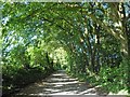
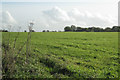
Broadrush Brake creates an avenue of trees
Image: © Steve Fareham
Taken: 21 May 2014
0.13 miles
2
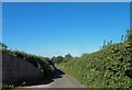
Bond Lane
An old drove road, now an unclassified county road and tunnel of green that forms part of the route of Jubilee Way http://www.ldwa.org.uk/ldp/members/show_path.php?path_name=Jubilee+Way+(South+Gloucestershire) http://www.southglos.gov.uk/_Resources/Publications/PTE/07/0200/PTE-07-0023
Image: © Robin Stott
Taken: 27 Oct 2010
0.16 miles
5
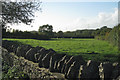
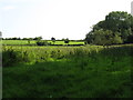
Field near Kyneton Park Lodge
The sombre local limestone forms a wall that commands respect.
Image: © Robin Stott
Taken: 27 Oct 2010
0.19 miles
7
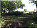
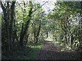
Junction of Bond Lane and a track
The latter is also a bridleway. Bond Lane, on the left, is an old drove road, an unclassified county road, a bridleway and part of the route of the Jubilee Way http://www.ldwa.org.uk/ldp/members/show_path.php?path_name=Jubilee+Way+(South+Gloucestershire) http://www.southglos.gov.uk/_Resources/Publications/PTE/07/0200/PTE-07-0023
Image: © Robin Stott
Taken: 27 Oct 2010
0.24 miles