IMAGES TAKEN NEAR TO
Mumbleys Lane, BRISTOL, BS35 3JU
Introduction
This page details the photographs taken nearby to Mumbleys Lane, BS35 3JU by members of the Geograph project.
The Geograph project started in 2005 with the aim of publishing, organising and preserving representative images for every square kilometre of Great Britain, Ireland and the Isle of Man.

There are currently over 7.5m images from over14,400 individuals and you can help contribute to the project by visiting https://www.geograph.org.uk
Image Map (Loading...)


Getting Data...Please wait
Leaflet Map data © OpenStreetMap
Images are licensed for reuse under creativecommons.org/licenses/by-sa/2.0
Notes
- Clicking on the map will re-center to the selected point.
- The higher the marker number, the further away the image location is from the centre of the postcode.
Image Listing (13 Images Found)
Images are licensed for reuse under creativecommons.org/licenses/by-sa/2.0
Image
Details
Distance


5

Ridge House and front garden, Mumbleys Plat
A couple of houses are perched on the ridge south of Kington, where Mumbleys Lane crosses Bond Lane, an old drove road.
Image: © Robin Stott
Taken: 27 Oct 2010
0.21 miles
8
Stone Stile, Thornbury GS9522
A stile to replace the front gate of Mulberry Cottage, Mumbleys Lane. The view looking to the house is Image
Image: © Mr Red
Taken: 23 Dec 2022
0.22 miles
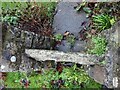
9

Stone Stile, Thornbury GS9522
A stile to replace the front gate of Mulberry Cottage, Mumbleys Lane, looking to the house. The view vertically down is Image
Image: © Mr Red
Taken: 23 Dec 2022
0.22 miles
10
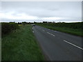
Vattingstone Lane (B4461), heading east
Towards Alveston.
Image: © JThomas
Taken: 11 May 2013
0.24 miles