IMAGES TAKEN NEAR TO
Thornbury Road, BRISTOL, BS35 3JB
Introduction
This page details the photographs taken nearby to Thornbury Road, BS35 3JB by members of the Geograph project.
The Geograph project started in 2005 with the aim of publishing, organising and preserving representative images for every square kilometre of Great Britain, Ireland and the Isle of Man.

There are currently over 7.5m images from over14,400 individuals and you can help contribute to the project by visiting https://www.geograph.org.uk
Image Map
Images are licensed for reuse under creativecommons.org/licenses/by-sa/2.0
Notes
- Clicking on the map will re-center to the selected point.
- The higher the marker number, the further away the image location is from the centre of the postcode.
Image Listing (6 Images Found)
Images are licensed for reuse under creativecommons.org/licenses/by-sa/2.0
Image
Details
Distance
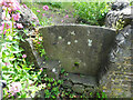
2
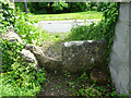
Stone Stile, Thornbury
Opposite the leisure centre, off the B4061, Bristol Road. On Gloucestershire footpath OTH/51 leading to the Munday Playing Fields. View looking is SE, the view from the road is Image
Image: © Mr Red
Taken: 17 May 2022
0.07 miles
3
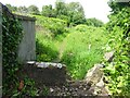
Stone Stile, Thornbury
Opposite the leisure centre, off the B4061, Bristol Road. On Gloucestershire footpath OTH/51 leading to the Munday Playing Fields. View looking is NW, the view towards the road is Image
Image: © Mr Red
Taken: 17 May 2022
0.07 miles
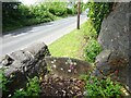
5
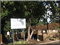
Stone Stile, Thornbury
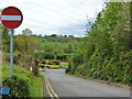
This view is from the B4061, Bristol Road, the view looking back is Image A pedestrian entrance to a small group of houses.
Image: © Mr Red
Taken: 17 May 2022
0.19 miles
6
Stone Stile, Thornbury
This view is looking to the B4061, Bristol Road, the view looking back is Image A pedestrian entrance to a small group of houses.
Image: © Mr Red
Taken: 17 May 2022
0.19 miles