IMAGES TAKEN NEAR TO
Pentland Avenue, BRISTOL, BS35 2YB
Introduction
This page details the photographs taken nearby to Pentland Avenue, BS35 2YB by members of the Geograph project.
The Geograph project started in 2005 with the aim of publishing, organising and preserving representative images for every square kilometre of Great Britain, Ireland and the Isle of Man.

There are currently over 7.5m images from over14,400 individuals and you can help contribute to the project by visiting https://www.geograph.org.uk
Image Map (Loading...)


Getting Data...Please wait
Leaflet Map data © OpenStreetMap
Images are licensed for reuse under creativecommons.org/licenses/by-sa/2.0
Notes
- Clicking on the map will re-center to the selected point.
- The higher the marker number, the further away the image location is from the centre of the postcode.
Image Listing (16 Images Found)
Images are licensed for reuse under creativecommons.org/licenses/by-sa/2.0
Image
Details
Distance
1
Cleveland Close, Thornbury
Viewed from Cheviot Drive. Cleveland Close is a cul-de-sac at the eastern edge of Thornbury.
Image: © Jaggery
Taken: 2 Jan 2012
0.09 miles
2
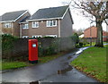
Postbox alongside Morton Way, Thornbury
The Queen Elizabeth II postbox is near a bus stop on Morton Way at the eastern edge of Thornbury.
Image: © Jaggery
Taken: 2 Jan 2012
0.12 miles
3
Path between Cleveland Close and Cumbria Close, Thornbury
Viewed from the Morton Way end. Cleveland Close is on the left, Cumbria Close on the right.
Image: © Jaggery
Taken: 2 Jan 2012
0.14 miles
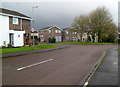
4
Eastern edge of Chiltern Park, Thornbury
Viewed from Morton Way. Chiltern Park is a cul-de-sac of about 40 houses at the SE edge of Thornbury.
Image: © Jaggery
Taken: 2 Jan 2012
0.14 miles
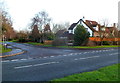
5
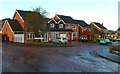
Chiltern Park houses, Thornbury
Viewed from near the Morton Way junction.
Chiltern Park is a cul-de-sac of about 40 houses at the SE edge of Thornbury.
Image: © Jaggery
Taken: 2 Jan 2012
0.15 miles
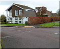
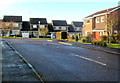
6
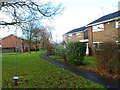
Malvern Drive
A quiet suburban road in Thornbury, a dormitary town for Bristol.
Image: © Jonathan Billinger
Taken: 15 Jan 2007
0.17 miles
7
Corner of Malvern Drive and Grovesend Road, Thornbury
Viewed across Grovesend Road.
Image: © Jaggery
Taken: 2 Jan 2012
0.17 miles
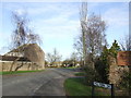
8
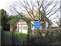
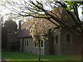
St Paul's church, The Hackett
On the edge of the dormitary town of Thornbury.
Image: © Jonathan Billinger
Taken: 15 Jan 2007
0.22 miles
9
Cumbria Close, Thornbury
Houses at the eastern edge of Thornbury viewed from the Morton Way end.
Image: © Jaggery
Taken: 2 Jan 2012
0.22 miles