IMAGES TAKEN NEAR TO
Orchard Avenue, BRISTOL, BS35 2LZ
Introduction
This page details the photographs taken nearby to Orchard Avenue, BS35 2LZ by members of the Geograph project.
The Geograph project started in 2005 with the aim of publishing, organising and preserving representative images for every square kilometre of Great Britain, Ireland and the Isle of Man.

There are currently over 7.5m images from over14,400 individuals and you can help contribute to the project by visiting https://www.geograph.org.uk
Image Map (Loading...)


Getting Data...Please wait
Leaflet Map data © OpenStreetMap
Images are licensed for reuse under creativecommons.org/licenses/by-sa/2.0
Notes
- Clicking on the map will re-center to the selected point.
- The higher the marker number, the further away the image location is from the centre of the postcode.
Image Listing (14 Images Found)
Images are licensed for reuse under creativecommons.org/licenses/by-sa/2.0
Image
Details
Distance
1
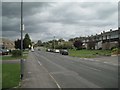
Knapp Road, Thornbury
Not far from its junction with Gillingstool and Grovesend Road, behind the camera.
Image: © Robin Stott
Taken: 18 Sep 2010
0.11 miles
2
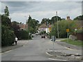
Easton Hill Road, Thornbury
Seen from its junction with Knapp Road.
Image: © Robin Stott
Taken: 18 Sep 2010
0.11 miles
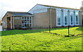
3
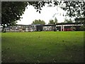
Crossways Junior School and Crossways Infant School
Seen from Knapp Road.
Image: © Robin Stott
Taken: 18 Sep 2010
0.14 miles
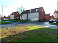
4
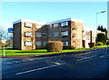
Cabot House, Thornbury
Located between Grovesend Road, Knapp Road and Sibland Road, Cabot House contains 15 flats.
This is the SW corner, viewed across Grovesend Road.
Image: © Jaggery
Taken: 2 Jan 2012
0.16 miles
5
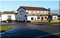
The Black Horse, Thornbury
Pub located on the north side of the road named Gillingstool.
Image: © Jaggery
Taken: 2 Jan 2012
0.17 miles
6
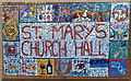
St Mary's Church Hall mosaic, Thornbury
The mosaic is on a side wall here. http://www.geograph.org.uk/photo/3396674
Image: © Jaggery
Taken: 2 Jan 2012
0.19 miles
7
St Mary's Church Hall, Thornbury
Set back from the south side of Eastbury Road.
This mosaic http://www.geograph.org.uk/photo/3396683 is on the side wall.
Image: © Jaggery
Taken: 2 Jan 2012
0.19 miles
8
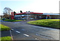
Murco Thornbury
The Murco filling station is located on the south side of the road named Gillingstool, next door to Thornbury Motors. The Black Horse http://www.geograph.org.uk/photo/3392151 is on the camera side of Gillingstool.
Image: © Jaggery
Taken: 2 Jan 2012
0.20 miles
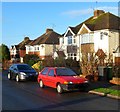
9
Pearce Close houses, Thornbury
Viewed across the road named Gillingstool.
Image: © Jaggery
Taken: 2 Jan 2012
0.22 miles
10
Eastbury Road houses, Thornbury
Viewed from near St Mary's Church Hall. http://www.geograph.org.uk/photo/3396674
Image: © Jaggery
Taken: 2 Jan 2012
0.23 miles