1
Market Square flats, Thornbury
The flats were built in 2008.
Image: © Jaggery
Taken: 1 Jan 2012
0.01 miles
2
Recently-built housing, Rock Street, Thornbury
Viewed from opposite the corner of Upper Bath Road. A plaque on the building records
that this was the site of Thornbury's historic cattle market.
Image: © Jaggery
Taken: 1 Jan 2012
0.01 miles
3
New housing at old cattle market
The plaque on this row of homes says: "This building has been constructed on the site of Thornbury's historic cattle market" - the gateway in front appears to be the only remaining original feature on the site.
Image: © Ruth Riddle
Taken: 27 Apr 2011
0.01 miles
4
Thornbury Police Station
Part of Avon and Somerset Constabulary, the police station is in Rock Street facing Chapel Street.
Image: © Jaggery
Taken: 1 Jan 2012
0.01 miles
5
Rock Street Garden, Thornbury
Created for the Britain in Bloom competition 1993. It's one of the stations on the informative Thornbury Heritage Trail. The big free Rock Street car park is across the road (Bath Road).
Image: © Robin Stott
Taken: 18 Sep 2010
0.02 miles
6
Sitting area, Bath Road, Thornbury
Bath Road is a cul-de-sac. The big free Rock Street car park is behind the landscaping on the left. There is a community centre off to the right somewhere.
The sitting area is a well-meant but misconceived townscape feature of the late 20th century. Most of them are unused. They should be documented before they are all swept away. This is a choice example. The best thing about it is the tree.
Image: © Robin Stott
Taken: 20 Sep 2010
0.02 miles
7
Recycling point, Rock Street car park, Thornbury
Bath Road, a cul-de-sac, is on the right.
Image: © Robin Stott
Taken: 20 Sep 2010
0.02 miles
8
Old Market Street, Thornbury
A view from the corner of Upper Bath Road.
Image: © Jaggery
Taken: 1 Jan 2012
0.03 miles
9
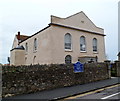
United Reformed Church, Thornbury
Located on the corner of Chapel Street and Rock Street.
Inscriptions on the church record that it was built as a Congregational Church in 1826.
Image: © Jaggery
Taken: 1 Jan 2012
0.03 miles
10
Community Garden
Image: © don cload
Taken: 7 Jun 2017
0.04 miles


