IMAGES TAKEN NEAR TO
Rock Street, BRISTOL, BS35 2BA
Introduction
This page details the photographs taken nearby to Rock Street, BS35 2BA by members of the Geograph project.
The Geograph project started in 2005 with the aim of publishing, organising and preserving representative images for every square kilometre of Great Britain, Ireland and the Isle of Man.

There are currently over 7.5m images from over14,400 individuals and you can help contribute to the project by visiting https://www.geograph.org.uk
Image Map (Loading...)


Getting Data...Please wait
Leaflet Map data © OpenStreetMap
Images are licensed for reuse under creativecommons.org/licenses/by-sa/2.0
Notes
- Clicking on the map will re-center to the selected point.
- The higher the marker number, the further away the image location is from the centre of the postcode.
Image Listing (262 Images Found)
Images are licensed for reuse under creativecommons.org/licenses/by-sa/2.0
Image
Details
Distance
1
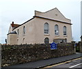
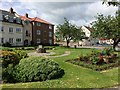
United Reformed Church, Thornbury
Located on the corner of Chapel Street and Rock Street.
Inscriptions on the church record that it was built as a Congregational Church in 1826.
Image: © Jaggery
Taken: 1 Jan 2012
0.01 miles
2
Thornbury, chapel
On Chapel Street, former Congregational chapel, now URC church, dated 1826. Listed by Historic England, Grade II: http://www.imagesofengland.org.uk/Details/Default.aspx?id=34920&mode=adv
Image: © Mike Faherty
Taken: 19 Mar 2017
0.02 miles
3
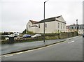
Thornbury Police Station
Part of Avon and Somerset Constabulary, the police station is in Rock Street facing Chapel Street.
Image: © Jaggery
Taken: 1 Jan 2012
0.03 miles
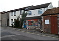
4
Recently-built housing, Rock Street, Thornbury
Viewed from opposite the corner of Upper Bath Road. A plaque on the building records
that this was the site of Thornbury's historic cattle market.
Image: © Jaggery
Taken: 1 Jan 2012
0.03 miles
6
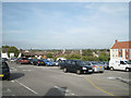
Rock Street car park, Thornbury.
Free! The historic town centre is on a hill, so there are these occasional views out across the south Gloucestershire countryside. The white building on the left is the Baptist church Image with the modern Baptist centre to its right. In the centre of the photo are the roofs of the Gillingstool school complex.
Image: © Robin Stott
Taken: 20 Sep 2010
0.03 miles
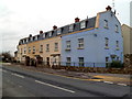
7
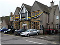
Wheatsheaf, Thornbury
Chapel Street pub viewed from the corner of St Mary Street.
Image: © Jaggery
Taken: 1 Jan 2012
0.03 miles
8
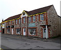
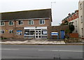
Businesses near the southern end of St Mary Street, Thornbury
Nearest the camera are Surroundings (gifts, cards, framing) and Grange Carpets.
Image: © Jaggery
Taken: 1 Jan 2012
0.03 miles
9
Ladbrokes Thornbury
The betting shop is at 22 St Mary Street.
St Mary Street Surgery is on the left.
Image: © Jaggery
Taken: 1 Jan 2012
0.03 miles
10
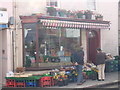
Riddifords General Store, Thornbury
The television comedy series 'Open All Hours' is reputed to have been based on this store.
Image: © Alan Kent
Taken: 25 Sep 2007
0.04 miles