IMAGES TAKEN NEAR TO
High Street, BRISTOL, BS35 2AS
Introduction
This page details the photographs taken nearby to High Street, BS35 2AS by members of the Geograph project.
The Geograph project started in 2005 with the aim of publishing, organising and preserving representative images for every square kilometre of Great Britain, Ireland and the Isle of Man.

There are currently over 7.5m images from over14,400 individuals and you can help contribute to the project by visiting https://www.geograph.org.uk
Image Map (Loading...)


Getting Data...Please wait
Leaflet Map data © OpenStreetMap
Images are licensed for reuse under creativecommons.org/licenses/by-sa/2.0
Notes
- Clicking on the map will re-center to the selected point.
- The higher the marker number, the further away the image location is from the centre of the postcode.
Image Listing (272 Images Found)
Images are licensed for reuse under creativecommons.org/licenses/by-sa/2.0
Image
Details
Distance
1

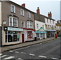
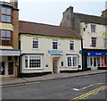
Three St Mary Street businesses, Thornbury
On the left is an entrance to the walk through store of Hawkins of Thornbury hardware and DiY merchants. In the middle is Lee's Mend-a-Shoe. A Lloyd's Pharmacy is on the right.
Image: © Jaggery
Taken: 1 Jan 2012
0.01 miles
2
Manns opticians, Thornbury
R.J.Manns Opticians is at 45 High Street.
The business also has practices in Yate, Chipping Sodbury, Filton and Wotton-Under-Edge.
On the right is a Lloyds Pharmacy and Hawkins of Thornbury hardware and DiY store.
Image: © Jaggery
Taken: 1 Jan 2012
0.02 miles
3
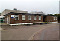
Thornbury Library
Located on St Mary Street, the library is one of fourteen operated by South Gloucestershire Council.
Image: © Jaggery
Taken: 1 Jan 2012
0.02 miles
4
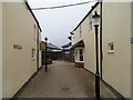
Horseshoe Lane, Thornbury
Viewed from St Mary Street in the pedestrianised shopping area of Thornbury.
Ahead on the right, beyond the projecting white window, is Norville Opticians, 6 Horseshoe Lane.
Image: © Jaggery
Taken: 1 Jan 2012
0.02 miles
5
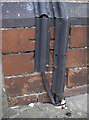
High Street benchmark
Still discernible despite the plastic trunking over the top. See Image] for a wider view and http://www.bench-marks.org.uk/bm57184 for the entry in the Benchmark Database.
Image: © Neil Owen
Taken: 5 May 2014
0.02 miles
6
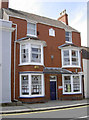
High Street offices
A typical office in an old building in a town High Street. Look carefully and there is a small tablet at the upper floor level that commemorates Queen Victoria's sixtieth - see Image] for a closer look. Number 38 also has a benchmark to its fame - see Image
Image: © Neil Owen
Taken: 5 May 2014
0.02 miles
7
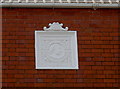
The Queen's sixtieth
An 1897 commemorative stone in an office building in Thornbury High Street. See Image] for a wider view.
Image: © Neil Owen
Taken: 5 May 2014
0.02 miles
8
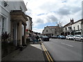
High Street, Thornbury
Thornbury was "Thornbyrig" in the 9th century, "Turnieberie" in the Domesday Book. The town charter was granted in 1252.
Image: © Bikeboy
Taken: 8 Apr 2014
0.03 miles
9
Barclays Bank, Thornbury
Bank branch at 41 High Street.
Image: © Jaggery
Taken: 1 Jan 2012
0.03 miles
10
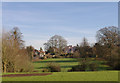
Rear view of High Street houses, Thornbury.
Looking East from the Mundy Playing Fields at some of the houses on the High Street.
Image: © Ken Wilkins
Taken: 9 Feb 2008
0.03 miles