IMAGES TAKEN NEAR TO
Nupdown Lane, BRISTOL, BS35 1RS
Introduction
This page details the photographs taken nearby to Nupdown Lane, BS35 1RS by members of the Geograph project.
The Geograph project started in 2005 with the aim of publishing, organising and preserving representative images for every square kilometre of Great Britain, Ireland and the Isle of Man.

There are currently over 7.5m images from over14,400 individuals and you can help contribute to the project by visiting https://www.geograph.org.uk
Image Map (Loading...)


Getting Data...Please wait
Leaflet Map data © OpenStreetMap
Images are licensed for reuse under creativecommons.org/licenses/by-sa/2.0
Notes
- Clicking on the map will re-center to the selected point.
- The higher the marker number, the further away the image location is from the centre of the postcode.
Image Listing (4 Images Found)
Images are licensed for reuse under creativecommons.org/licenses/by-sa/2.0
Image
Details
Distance
1
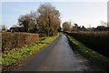
Country road through Nupdown
Country road through Nupdown in the Vale of Berkeley.
Image: © Philip Halling
Taken: 24 Jan 2015
0.04 miles
2
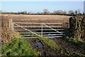
Field gate at Nupdown
Field gate at Nupdown in the Vale of Berkeley.
Image: © Philip Halling
Taken: 24 Jan 2015
0.10 miles
4
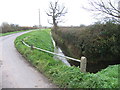
A junction of rhines
There are very many rhines (drainage ditches) in this area. Here, the two pictured rhines converge, along with a further drainage tunnel that goes beneath the white guard-rail to meet two similarly converging rhines on the other side of the road.
Image: © Ruth Riddle
Taken: 26 Nov 2011
0.24 miles