IMAGES TAKEN NEAR TO
Whitfield Road, BRISTOL, BS35 1JR
Introduction
This page details the photographs taken nearby to Whitfield Road, BS35 1JR by members of the Geograph project.
The Geograph project started in 2005 with the aim of publishing, organising and preserving representative images for every square kilometre of Great Britain, Ireland and the Isle of Man.

There are currently over 7.5m images from over14,400 individuals and you can help contribute to the project by visiting https://www.geograph.org.uk
Image Map (Loading...)


Getting Data...Please wait
Leaflet Map data © OpenStreetMap
Images are licensed for reuse under creativecommons.org/licenses/by-sa/2.0
Notes
- Clicking on the map will re-center to the selected point.
- The higher the marker number, the further away the image location is from the centre of the postcode.
Image Listing (25 Images Found)
Images are licensed for reuse under creativecommons.org/licenses/by-sa/2.0
Image
Details
Distance
1
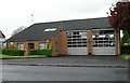
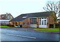
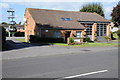
Thornbury Fire Station
Thornbury Fire Station, Gloucester Road, Thornbury, Bristol is station number 02 of Avon Fire & Rescue Service
Image: © Kevin Hale
Taken: 8 May 2006
0.07 miles
2
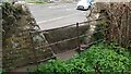
Stone Stile, Park Road GS9529
Off Park Road, near Manorbrook School on Gloucestershire footpath OTH/83 looking South from the road.
The view North is Image
Image: © Richard Laycock
Taken: 29 Mar 2021
0.07 miles
3
Stone Stile, Park Road GS9529
Off Park Road, near Manorbrook School on Gloucestershire footpath OTH/83 looking North.
The view South is Image
Image: © Richard Laycock
Taken: 29 Mar 2021
0.07 miles
4
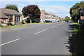
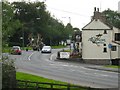
Gloucester Road, Thornbury
View along Gloucester Road in Thornbury, the fire station can be seen on the left.
Image: © Philip Halling
Taken: 29 Sep 2012
0.08 miles
5
Thornbury Fire Station
Viewed across Gloucester Road. Part of Avon Fire & Rescue service, the current fire station was built in 1980.
Image: © Jaggery
Taken: 2 Jan 2012
0.10 miles
6
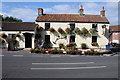
The Anchor Inn, Morton Bridge
The Anchor Inn at Morton Bridge in Thornbury.
Image: © Philip Halling
Taken: 29 Sep 2012
0.10 miles
7
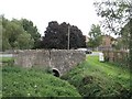
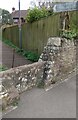
Morton Bridge, Gloucester Road
Seen from Streamside Walk Linear Park by Charles Close. That's a worrying crack in the parapet wall. The stream flows west, towards the camera.
Image: © Robin Stott
Taken: 18 Sep 2010
0.10 miles
8
Farm traffic in Thornbury
On Gloucester Road B4061 just at the edge of the square south of Morton Bridge and the Anchor Inn.
Image: © Robin Stott
Taken: 18 Sep 2010
0.10 miles
9
Thornbury Fire Station
Thornbury Fire Station on Gloucester Road, Thornbury.
Image: © Philip Halling
Taken: 29 Sep 2012
0.10 miles
10
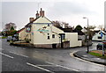
The Anchor Inn, Thornbury
On the corner of Gloucester Road and Park Road in the Morton area of Thornbury.
Image: © Jaggery
Taken: 2 Jan 2012
0.10 miles