IMAGES TAKEN NEAR TO
Church Road, BRISTOL, BS35 1HL
Introduction
This page details the photographs taken nearby to Church Road, BS35 1HL by members of the Geograph project.
The Geograph project started in 2005 with the aim of publishing, organising and preserving representative images for every square kilometre of Great Britain, Ireland and the Isle of Man.

There are currently over 7.5m images from over14,400 individuals and you can help contribute to the project by visiting https://www.geograph.org.uk
Image Map (Loading...)


Getting Data...Please wait
Leaflet Map data © OpenStreetMap
Images are licensed for reuse under creativecommons.org/licenses/by-sa/2.0
Notes
- Clicking on the map will re-center to the selected point.
- The higher the marker number, the further away the image location is from the centre of the postcode.
Image Listing (157 Images Found)
Images are licensed for reuse under creativecommons.org/licenses/by-sa/2.0
Image
Details
Distance
1
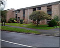
Park Road housing, Thornbury
Viewed from near East Lodge. http://www.geograph.org.uk/photo/3405256
Image: © Jaggery
Taken: 1 Jan 2012
0.05 miles
2
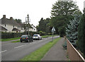
Park Road looking west
Alongside Castle School grounds, right.
Image: © Robin Stott
Taken: 18 Sep 2010
0.05 miles
3
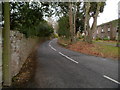
Park Road, Thornbury
Viewed from near East Lodge. http://www.geograph.org.uk/photo/3405256
Park Road heads towards the Morton district of Thornbury.
Image: © Jaggery
Taken: 1 Jan 2012
0.06 miles
4
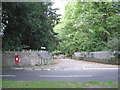
Drive and footpath north of Park Road, Thornbury
Postbox number BS35 174
Image: © Robin Stott
Taken: 18 Sep 2010
0.06 miles
5
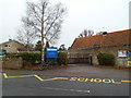
Entrance to St Mary's C of E primary school, Thornbury
Viewed across Church Road. St. Mary’s is a Voluntary Aided Church of England Primary School.
The nameboard shows the year 1839.
Image: © Jaggery
Taken: 1 Jan 2012
0.06 miles
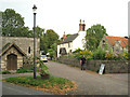
6
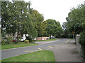
Church Road, Thornbury
Near St Mary's C of E Primary School.
Image: © Robin Stott
Taken: 18 Sep 2010
0.07 miles
7
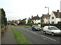
Park Road looking east
Detached houses overlook Castle School grounds.
Image: © Robin Stott
Taken: 18 Sep 2010
0.08 miles
8
An entrance to Thornbury castle
Viewed from Park Road looking past East Lodge which was built c1855 in the Tudor Gothic style.
Image: © Jaggery
Taken: 1 Jan 2012
0.08 miles
9
The Pound and Pound Cottage, Park Road
On the right is part of St Mary's C of E Primary School.
Image: © Robin Stott
Taken: 18 Sep 2010
0.09 miles
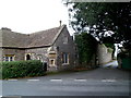
10
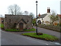
Grade II listed former lockup and pound, Thornbury
Located between Park Road and Church Road, the early 19th century lockup was formerly used as a jail and the pound at the back was for stray animals. The two small slits for windows give the impression
of a small medieval castle, which is perhaps what its designers intended.
Grade II listed in December 1984.
Image: © Jaggery
Taken: 1 Jan 2012
0.09 miles