IMAGES TAKEN NEAR TO
Stokefield Close, BRISTOL, BS35 1HE
Introduction
This page details the photographs taken nearby to Stokefield Close, BS35 1HE by members of the Geograph project.
The Geograph project started in 2005 with the aim of publishing, organising and preserving representative images for every square kilometre of Great Britain, Ireland and the Isle of Man.

There are currently over 7.5m images from over14,400 individuals and you can help contribute to the project by visiting https://www.geograph.org.uk
Image Map (Loading...)


Getting Data...Please wait
Leaflet Map data © OpenStreetMap
Images are licensed for reuse under creativecommons.org/licenses/by-sa/2.0
Notes
- Clicking on the map will re-center to the selected point.
- The higher the marker number, the further away the image location is from the centre of the postcode.
Image Listing (322 Images Found)
Images are licensed for reuse under creativecommons.org/licenses/by-sa/2.0
Image
Details
Distance
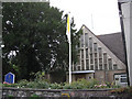
1
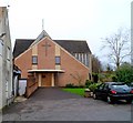
Christ the King Catholic Church, Thornbury
Set back from the west side of Castle Street, Thornbury's Roman Catholic Church is part of the Diocese of Clifton. It covers a wide area adjacent to the River Severn, from Aust to Purton on one side and beyond the M5 motorway on the other side.
Image: © Jaggery
Taken: 1 Jan 2012
0.02 miles
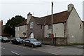
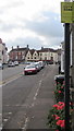
2
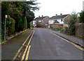
Stokefield Close houses, Thornbury
Viewed from the Castle Street end.
Image: © Jaggery
Taken: 1 Jan 2012
0.02 miles
3
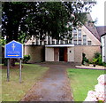
Roman Catholic church, Thornbury
Set back from the west side of Castle Street, Christ the King Catholic Church is part of the Roman Catholic Diocese of Clifton.
Image: © Jaggery
Taken: 2 Aug 2020
0.03 miles
5
Christ the King church hall, Thornbury
Viewed across Castle Street. The church http://www.geograph.org.uk/photo/3117129 is set back from the road.
Image: © Jaggery
Taken: 1 Jan 2012
0.03 miles
6
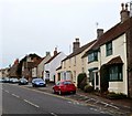
West side of Castle Street, Thornbury
A view south from opposite the Stokefield Close junction.
Image: © Jaggery
Taken: 1 Jan 2012
0.03 miles
7
Roman Catholic Church of Christ the King, Castle Street
Image: © Robin Stott
Taken: 18 Sep 2010
0.04 miles
8
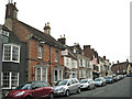
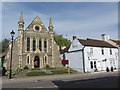
Top of Castle Street, Thornbury: 1
Looking up towards The Plain. Brick building is Oriel House Business Centre.
Image: © Robin Stott
Taken: 18 Sep 2010
0.04 miles
9
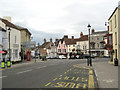
Top of Castle Street, Thornbury: 2
Looking from the bottom of High Street B4061, with The Plain (a town-centre Z-bend) round to the right.
Image: © Robin Stott
Taken: 18 Sep 2010
0.04 miles
10
Yellow CCTV Zone notice, Castle Street, Thornbury
Text on the Closed Circuit Television notice in August 2020 includes
"The scheme is controlled by South Gloucestershire Council and Thornbury Town Council"
Image: © Jaggery
Taken: 2 Aug 2020
0.04 miles