IMAGES TAKEN NEAR TO
Castle Street, BRISTOL, BS35 1HA
Introduction
This page details the photographs taken nearby to Castle Street, BS35 1HA by members of the Geograph project.
The Geograph project started in 2005 with the aim of publishing, organising and preserving representative images for every square kilometre of Great Britain, Ireland and the Isle of Man.

There are currently over 7.5m images from over14,400 individuals and you can help contribute to the project by visiting https://www.geograph.org.uk
Image Map (Loading...)


Getting Data...Please wait
Leaflet Map data © OpenStreetMap
Images are licensed for reuse under creativecommons.org/licenses/by-sa/2.0
Notes
- Clicking on the map will re-center to the selected point.
- The higher the marker number, the further away the image location is from the centre of the postcode.
Image Listing (307 Images Found)
Images are licensed for reuse under creativecommons.org/licenses/by-sa/2.0
Image
Details
Distance
1
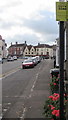
Yellow CCTV Zone notice, Castle Street, Thornbury
Text on the Closed Circuit Television notice in August 2020 includes
"The scheme is controlled by South Gloucestershire Council and Thornbury Town Council"
Image: © Jaggery
Taken: 2 Aug 2020
0.00 miles
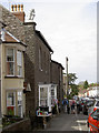
2
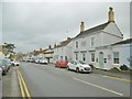
Thornbury, Castle Street
The continuation North of High Street; a mixture of commercial and residential small properties.
Image: © Mike Faherty
Taken: 19 Mar 2017
0.01 miles
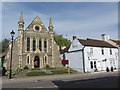
3
Christ the King church hall, Thornbury
Viewed across Castle Street. The church http://www.geograph.org.uk/photo/3117129 is set back from the road.
Image: © Jaggery
Taken: 1 Jan 2012
0.01 miles
4
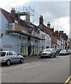
Castle Street scaffolding, Thornbury
Viewed in early August 2020.
Image: © Jaggery
Taken: 2 Aug 2020
0.01 miles
5
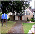
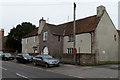
Roman Catholic church, Thornbury
Set back from the west side of Castle Street, Christ the King Catholic Church is part of the Roman Catholic Diocese of Clifton.
Image: © Jaggery
Taken: 2 Aug 2020
0.01 miles
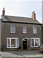
7
Rooftop guardian
Lion House in Castle Street dates from the eighteenth century and has had a host of owners since. Originally it was not named as such but it seems to have been The Black Lion pub during its time (the White Lion pub is just a short stagger up the road, incidentally). Hence the house is known as Lion House and has a statue on top of the coping. See Image] for a closer look.
Image: © Neil Owen
Taken: 5 May 2014
0.02 miles
8
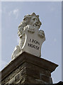
Lion House
This small but redoubtable figure sits on top of the copings of Lion House. A former occupier was a local vet, John James, who carried out a lot of renovations and perhaps added this appropriate chap. See Image] for a wider view.
Image: © Neil Owen
Taken: 5 May 2014
0.02 miles
9
Lion House
Today this period house is host to a local arts day. The Severn Vale Arts Trail opened a number of sites for people to see lots of local pieces. Notice the white lion on the end of the roof coping - Image
Image: © Neil Owen
Taken: 5 May 2014
0.02 miles
10
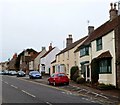
West side of Castle Street, Thornbury
A view south from opposite the Stokefield Close junction.
Image: © Jaggery
Taken: 1 Jan 2012
0.02 miles