IMAGES TAKEN NEAR TO
Chatsworth Gardens, BRISTOL, BS35 1GZ
Introduction
This page details the photographs taken nearby to Chatsworth Gardens, BS35 1GZ by members of the Geograph project.
The Geograph project started in 2005 with the aim of publishing, organising and preserving representative images for every square kilometre of Great Britain, Ireland and the Isle of Man.

There are currently over 7.5m images from over14,400 individuals and you can help contribute to the project by visiting https://www.geograph.org.uk
Image Map
Images are licensed for reuse under creativecommons.org/licenses/by-sa/2.0
Notes
- Clicking on the map will re-center to the selected point.
- The higher the marker number, the further away the image location is from the centre of the postcode.
Image Listing (26 Images Found)
Images are licensed for reuse under creativecommons.org/licenses/by-sa/2.0
Image
Details
Distance
1
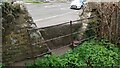
Stone Stile, Park Road GS9529
Off Park Road, near Manorbrook School on Gloucestershire footpath OTH/83 looking South from the road.
The view North is Image
Image: © Richard Laycock
Taken: 29 Mar 2021
0.02 miles
2
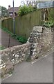
Stone Stile, Park Road GS9529
Off Park Road, near Manorbrook School on Gloucestershire footpath OTH/83 looking North.
The view South is Image
Image: © Richard Laycock
Taken: 29 Mar 2021
0.02 miles
4
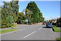
Park Road, Thornbury
Park Road in Thornbury, pictured here where it passes Manorbrook Primary School.
Image: © Philip Halling
Taken: 29 Sep 2012
0.06 miles
5
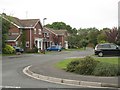
Manorbrook Primary School
Seen from the entrance in Park Road.
Image: © Robin Stott
Taken: 18 Sep 2010
0.09 miles
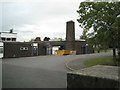
6
Thornbury Fire Station
Thornbury Fire Station, Gloucester Road, Thornbury, Bristol is station number 02 of Avon Fire & Rescue Service
Image: © Kevin Hale
Taken: 8 May 2006
0.10 miles
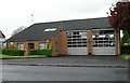
7
Thornbury Fire Station
Viewed across Gloucester Road. Part of Avon Fire & Rescue service, the current fire station was built in 1980.
Image: © Jaggery
Taken: 2 Jan 2012
0.11 miles
8
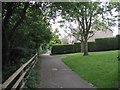
Streamside Walk Linear Park: 2
Approaching Pittville Close before turning left to cross the stream. A plaque there marks the site of a mediaeval corn mill.
Image: © Robin Stott
Taken: 18 Sep 2010
0.11 miles
9
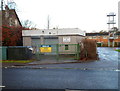
Bristol ACF Thornbury Detachment
The Thornbury Detachment of Bristol ACF (Army Cadet Force) is located in Gloucester Road next door to the fire station. http://www.geograph.org.uk/photo/3396558 The fire station training tower is in the background.
Image: © Jaggery
Taken: 2 Jan 2012
0.12 miles
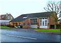
10
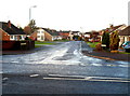
Dean Avenue, Thornbury
Viewed across Gloucester Road in the Morton district of Thornbury.
Image: © Jaggery
Taken: 2 Jan 2012
0.12 miles