IMAGES TAKEN NEAR TO
Orchard Grange, BRISTOL, BS35 1EW
Introduction
This page details the photographs taken nearby to Orchard Grange, BS35 1EW by members of the Geograph project.
The Geograph project started in 2005 with the aim of publishing, organising and preserving representative images for every square kilometre of Great Britain, Ireland and the Isle of Man.

There are currently over 7.5m images from over14,400 individuals and you can help contribute to the project by visiting https://www.geograph.org.uk
Image Map (Loading...)


Getting Data...Please wait
Leaflet Map data © OpenStreetMap
Images are licensed for reuse under creativecommons.org/licenses/by-sa/2.0
Notes
- Clicking on the map will re-center to the selected point.
- The higher the marker number, the further away the image location is from the centre of the postcode.
Image Listing (229 Images Found)
Images are licensed for reuse under creativecommons.org/licenses/by-sa/2.0
Image
Details
Distance
1
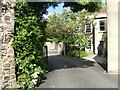
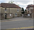
Chantry Entrance, Thornbury, Gloucestershire
The Chantry is a listed building, partly dating to Tudor times, probably used originally as a chapel, now run as a Community Centre for the benefit of Thornbury and hosting many varied activities
Image: © Anita Bailey
Taken: 16 May 2005
0.05 miles
2
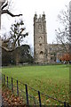
Thornbury church
St Mary the Virgin.
Looking N from position
Image: © Iain Macaulay
Taken: 20 Dec 2005
0.05 miles
3
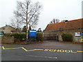
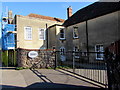
Entrance to St Mary's C of E primary school, Thornbury
Viewed across Church Road. St. Mary’s is a Voluntary Aided Church of England Primary School.
The nameboard shows the year 1839.
Image: © Jaggery
Taken: 1 Jan 2012
0.06 miles
4
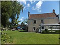
The grounds of The Chantry
The Chantry is a community centre for Thornbury
Image: © David Smith
Taken: 28 Jul 2012
0.06 miles
5
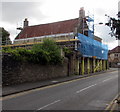
Castle Street scaffolding, Thornbury
Viewed in early August 2020.
Image: © Jaggery
Taken: 2 Aug 2020
0.06 miles
6
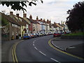
Castle Street, Thornbury
I took this shot because of the mixture of colours that the houses are painted.
Image: © Stephen Nicholls
Taken: 29 Jun 2005
0.07 miles
7
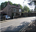
Stone cottage, Castle Street, Thornbury
On the north side of Castle Street viewed from the corner of Kington Lane.
Image: © Jaggery
Taken: 2 Aug 2020
0.07 miles
8
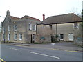
The Chantry Community Centre, Thornbury
Viewed across Castle Street. On the right is the entrance to the Chantry, a building dating in part from the Tudor era. Since the early 1970s, it has been owned by, and the home of, Thornbury and District Community Association (TDCA), a registered charity. TDCA runs the community centre for the benefit of the residents of Thornbury and surrounding areas.
Image: © Jaggery
Taken: 1 Jan 2012
0.07 miles
9
Chantry, 52 Castle Street, Thornbury
Chantry Community and Arts Centre is set back from Castle Street.
Image: © Jaggery
Taken: 2 Aug 2020
0.07 miles
10
Chantry entrance gates, 52 Castle Street, Thornbury
At the entrance to Chantry Community and Arts Centre.
Image: © Jaggery
Taken: 2 Aug 2020
0.07 miles