1
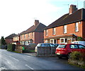
Church Road houses, Thornbury
The houses are on the north side of Church Road, viewed from the Gloucester Road end.
Some references show Church Lane. A name sign out of shot nearby shows Church Road.
Image: © Jaggery
Taken: 2 Jan 2012
0.08 miles
2
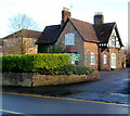
End property, Tilting Road, Thornbury
A Pyracantha hedge to land at the side lights up Park Road.
Image: © Robin Stott
Taken: 18 Sep 2010
0.10 miles
3
Park Road looking east
Detached houses overlook Castle School grounds.
Image: © Robin Stott
Taken: 18 Sep 2010
0.10 miles
4
The Castle School, Park Road
Image: © Robin Stott
Taken: 18 Sep 2010
0.11 miles
5
Gloucester Road crosses a weak bridge, Thornbury
Opposite the Church Road junction on the left, the B4061 Gloucester Road crosses a stream.
Signs show an 18 tonne weight limit over this http://www.geograph.org.uk/photo/3396794 bridge.
Image: © Jaggery
Taken: 2 Jan 2012
0.11 miles
6
A weak bridge, Thornbury
The bridge carries the B4061 Gloucester Road over a stream.
The sign on the left http://www.geograph.org.uk/photo/3396785 shows an 18 tonne weight limit.
Image: © Jaggery
Taken: 2 Jan 2012
0.12 miles
7
Pink houses, Buckingham Parade, Thornbury
Viewed across Gloucester Road.
Image: © Jaggery
Taken: 2 Jan 2012
0.14 miles
8
The Castle School Sixth Form Centre, Thornbury
Viewed from Gloucester Road. The main part of the Castle School is in Park Road, Thornbury.
Image: © Jaggery
Taken: 2 Jan 2012
0.14 miles
9
Dean Avenue, Thornbury
The north end, seen from Park Road.
Image: © Robin Stott
Taken: 18 Sep 2010
0.15 miles
10
Council Social Services Department, Thornbury
The South Gloucestershire Council offices are in Gloucester Road.
Image: © Jaggery
Taken: 2 Jan 2012
0.15 miles


