1
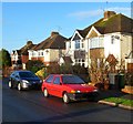
North Road, Thornbury
A view north from near the corner of Eastland Road.
Image: © Jaggery
Taken: 2 Jan 2012
0.02 miles
2
Thornbury Fire Station
Thornbury Fire Station on Gloucester Road, Thornbury.
Image: © Philip Halling
Taken: 29 Sep 2012
0.08 miles
3
Bristol ACF Thornbury Detachment
The Thornbury Detachment of Bristol ACF (Army Cadet Force) is located in Gloucester Road next door to the fire station. http://www.geograph.org.uk/photo/3396558 The fire station training tower is in the background.
Image: © Jaggery
Taken: 2 Jan 2012
0.08 miles
4
Thornbury Fire Station
Viewed across Gloucester Road. Part of Avon Fire & Rescue service, the current fire station was built in 1980.
Image: © Jaggery
Taken: 2 Jan 2012
0.08 miles
5
Gloucester Road, Thornbury
View along Gloucester Road in Thornbury, the fire station can be seen on the left.
Image: © Philip Halling
Taken: 29 Sep 2012
0.09 miles
6
Thornbury Fire Station
Thornbury Fire Station, Gloucester Road, Thornbury, Bristol is station number 02 of Avon Fire & Rescue Service
Image: © Kevin Hale
Taken: 8 May 2006
0.11 miles
7
Former Thornbury workhouse
Viewed from the corner of Gloucester Road and Eastland Road. Now converted to flats named Beechacres, this was formerly Thornbury Workhouse. The main block, part of which is in the background, dates from 1837. The porter's lodge on the left shows the year 1888.
Workhouses were used for poor relief in the Victorian era (and later) throughout the UK. They were places of dread for the needy poor and elderly, who had no alternatives in the days before the Welfare State. Books such as Charles Dickens' Oliver Twist highlighted conditions in the workhouse.
Workhouse life was deliberately made as harsh and degrading as possible so that only the truly destitute would apply.
Image: © Jaggery
Taken: 2 Jan 2012
0.12 miles
8
Eastbury Road houses, Thornbury
Viewed from near St Mary's Church Hall. http://www.geograph.org.uk/photo/3396674
Image: © Jaggery
Taken: 2 Jan 2012
0.12 miles
9
Dean Avenue, Thornbury
Viewed across Gloucester Road in the Morton district of Thornbury.
Image: © Jaggery
Taken: 2 Jan 2012
0.12 miles
10
Gloucester Road crosses a weak bridge, Thornbury
Opposite the Church Road junction on the left, the B4061 Gloucester Road crosses a stream.
Signs show an 18 tonne weight limit over this http://www.geograph.org.uk/photo/3396794 bridge.
Image: © Jaggery
Taken: 2 Jan 2012
0.14 miles


