IMAGES TAKEN NEAR TO
William Street, BRISTOL, BS3 4TX
Introduction
This page details the photographs taken nearby to William Street, BS3 4TX by members of the Geograph project.
The Geograph project started in 2005 with the aim of publishing, organising and preserving representative images for every square kilometre of Great Britain, Ireland and the Isle of Man.

There are currently over 7.5m images from over14,400 individuals and you can help contribute to the project by visiting https://www.geograph.org.uk
Image Map
Images are licensed for reuse under creativecommons.org/licenses/by-sa/2.0
Notes
- Clicking on the map will re-center to the selected point.
- The higher the marker number, the further away the image location is from the centre of the postcode.
Image Listing (327 Images Found)
Images are licensed for reuse under creativecommons.org/licenses/by-sa/2.0
Image
Details
Distance
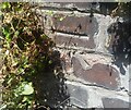
1
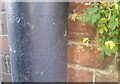
Ordnance Survey Cut Mark
This OS cut mark can be found on the wall junction of Nos. 70 & 71 William Street. It marks a point 38.377m above mean sea level.
Image: © Adrian Dust
Taken: 20 Jul 2021
0.01 miles
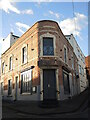
2
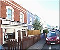
Henry Street, Totterdown, Bristol
The Shakespeare public house.
Image: © David Hallam-Jones
Taken: 11 Aug 2017
0.03 miles
3
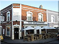
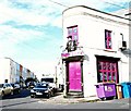
Culture in Totterdown
Good food, good wine and good company - quite the pleasure. All are on offer in William Street. The only people who aren't welcome are those who are bard...
Image: © Neil Owen
Taken: 20 Jan 2022
0.03 miles
4
The Thali Cafe
Looking along William Street at the junction with Cambridge Street.
Image: © DS Pugh
Taken: 27 Jun 2017
0.04 miles
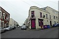
5
Cambridge Street, Totterdown, Bristol
The “Thali" cafe, occupying a triangular site at the junction of William Street and Cambridge Street, features a large bust of Raisa Gorbachev above its front door. This dates from the 1988 when the cafe was previously the “Glasnost bistro". Between c.1870 and 1940 this was a public house called “The Old King William Hotel” .
Image: © David Hallam-Jones
Taken: 11 Aug 2017
0.04 miles
6
Amba House
This was once a pub; it stands opposite what is now the Shakespeare pub, and seems to have shut when the latter opened. The building now serves as a community cafe and venue space hire.
Image: © Neil Owen
Taken: 20 Jan 2022
0.04 miles
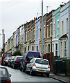
7
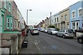
William Street
Looking along William Street consisting of terraced housing.
Image: © DS Pugh
Taken: 27 Jun 2017
0.05 miles
8
Ordnance Survey Cut Mark
This OS cut mark can be found on the wall junction of Nos. 28 & 29 William Street. It marks a point 38.167m above mean sea level.
Image: © Adrian Dust
Taken: 20 Jul 2021
0.06 miles
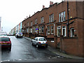
9
Green Street
Looking in from Pylle Hill Crescent, near the mosque.
Image: © Thomas Nugent
Taken: 16 Aug 2011
0.06 miles
10
William Street
Looking in from Pylle Hill Crescent.
Image: © Thomas Nugent
Taken: 16 Aug 2011
0.06 miles