IMAGES TAKEN NEAR TO
St. Lukes Road, BRISTOL, BS3 4RY
Introduction
This page details the photographs taken nearby to St. Lukes Road, BS3 4RY by members of the Geograph project.
The Geograph project started in 2005 with the aim of publishing, organising and preserving representative images for every square kilometre of Great Britain, Ireland and the Isle of Man.

There are currently over 7.5m images from over14,400 individuals and you can help contribute to the project by visiting https://www.geograph.org.uk
Image Map
Images are licensed for reuse under creativecommons.org/licenses/by-sa/2.0
Notes
- Clicking on the map will re-center to the selected point.
- The higher the marker number, the further away the image location is from the centre of the postcode.
Image Listing (233 Images Found)
Images are licensed for reuse under creativecommons.org/licenses/by-sa/2.0
Image
Details
Distance
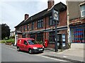
1
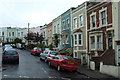
St Luke's Road, Knowle
A terrace by the Star & Dove pub (left).
Image: © Derek Harper
Taken: 15 Mar 2014
0.01 miles
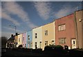
3
Colours of St Luke's Hill
The old terraces (or at least the ones that survived the post-war decimation in the name of town planning) are proud to sport some colour.
Image: © Neil Owen
Taken: 5 May 2022
0.02 miles
4
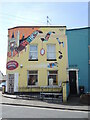
Piglet's Antiques
A corner shop on St John's Lane, brightly decorated since it was opened a few years ago. Prior to that, it was a domestic appliances shop and far more dowdy in appearance. The site is actually an old pub, known as the Boar's Head; before Totterdown was decimated by the bulldozers, there was another pub (the Three Elms) immediately opposite but that and the terraced houses are gone.
As with most of the houses hereabouts, the walls are treated to some non-standard paint - an effort that includes the street name plate.
Image: © Neil Owen
Taken: 5 May 2022
0.02 miles
5
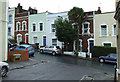
Stevens Crescent
Looking into Stevens Crescent from Windsor Terrace.
Image: © Thomas Nugent
Taken: 16 Aug 2011
0.02 miles
6
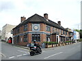
The Star and Dove
One of Totterdown's remaining pubs the Star and Dove was an original feature of the new suburb as it was built in the mid-1800s, when it was known as the Cumberland Hotel.
Image: © Neil Owen
Taken: 5 May 2022
0.03 miles
7
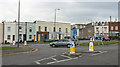
2010 : Roundabout on St. John's Lane
At its junction with St. Luke's Road and Ravenhill Road.
Be very careful in this area, the premises opposite advertises martial arts training.
Image: © Maurice Pullin
Taken: 7 Nov 2010
0.03 miles
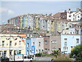
8
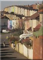
Terraces, Knowle
The residents hereabouts aren't shy of a bit of bright colour on their houses. In the foreground is Ravenhill Road; in the middle is St Luke's Road; and up on the hill is Pylle Hill Crescent.
Image: © Derek Harper
Taken: 15 Mar 2014
0.03 miles
9
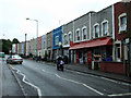
Shops on St Luke's Road
At the junction with Windsor Terrace.
Image: © Thomas Nugent
Taken: 16 Aug 2011
0.03 miles
10
Windsor Terrace
Viewed from Pylle Hill Crescent.
Image: © Thomas Nugent
Taken: 16 Aug 2011
0.04 miles