IMAGES TAKEN NEAR TO
Paultow Road, BRISTOL, BS3 4PT
Introduction
This page details the photographs taken nearby to Paultow Road, BS3 4PT by members of the Geograph project.
The Geograph project started in 2005 with the aim of publishing, organising and preserving representative images for every square kilometre of Great Britain, Ireland and the Isle of Man.

There are currently over 7.5m images from over14,400 individuals and you can help contribute to the project by visiting https://www.geograph.org.uk
Image Map
Images are licensed for reuse under creativecommons.org/licenses/by-sa/2.0
Notes
- Clicking on the map will re-center to the selected point.
- The higher the marker number, the further away the image location is from the centre of the postcode.
Image Listing (100 Images Found)
Images are licensed for reuse under creativecommons.org/licenses/by-sa/2.0
Image
Details
Distance
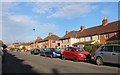
1
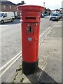
A St John's Lane letterbox
A Victorian letterbox by Handysides, on St John's Lane. The north side of the road was built around the late Victorian era, so perhaps the box is an original feature.
Image: © Neil Owen
Taken: 22 Feb 2022
0.03 miles
3
Fancy school railings
An interesting design to the Atlas Road side of Victoria Park junior school.
Image: © Neil Owen
Taken: 22 Feb 2022
0.06 miles
4
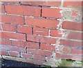
Ordnance Survey Cut Mark
This OS cut mark can be found on the school building on Atlas Road. It marks a point 16.090m above mean sea level.
Image: © Adrian Dust
Taken: 12 Mar 2020
0.06 miles
6
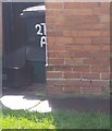
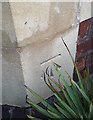
Ordnance Survey Cut Mark
This OS cut mark can be found on No271 St Johns Lane. It marks a point 13.929m above mean sea level.
Image: © Adrian Dust
Taken: 12 Mar 2020
0.08 miles
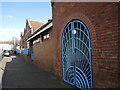
7
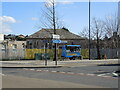
Some nosh outside the clinic
St John's Lane clinic was built before WWII and had provided medical help since then. Meanwhile, a mobile kitchen awaits some customers who aren't too ill to eat.
Image: © Neil Owen
Taken: 22 Feb 2022
0.08 miles
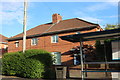
8
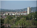
A Windmill Hill skyline
The tower block of Holroyd House is one of the obvious features, but the terraces provide some varied colour.
Image: © Neil Owen
Taken: 26 Apr 2022
0.11 miles
9
Ordnance Survey Cut Mark
This OS cut mark can be found on The Victoria Park PH. It marks a point 32.038m above mean sea level.
Image: © Adrian Dust
Taken: 12 Mar 2020
0.11 miles
10
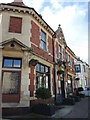
The Victoria Park pub and kitchen
Formerly the Raymend Hotel until fairly recently, when it was taken over as a community asset. On the corner is a benchmark - see Image
Image: © Neil Owen
Taken: 22 Feb 2022
0.11 miles