IMAGES TAKEN NEAR TO
Brendon Road, BRISTOL, BS3 4PL
Introduction
This page details the photographs taken nearby to Brendon Road, BS3 4PL by members of the Geograph project.
The Geograph project started in 2005 with the aim of publishing, organising and preserving representative images for every square kilometre of Great Britain, Ireland and the Isle of Man.

There are currently over 7.5m images from over14,400 individuals and you can help contribute to the project by visiting https://www.geograph.org.uk
Image Map
Images are licensed for reuse under creativecommons.org/licenses/by-sa/2.0
Notes
- Clicking on the map will re-center to the selected point.
- The higher the marker number, the further away the image location is from the centre of the postcode.
Image Listing (215 Images Found)
Images are licensed for reuse under creativecommons.org/licenses/by-sa/2.0
Image
Details
Distance
1
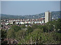
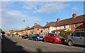
A Windmill Hill skyline
The tower block of Holroyd House is one of the obvious features, but the terraces provide some varied colour.
Image: © Neil Owen
Taken: 26 Apr 2022
0.03 miles
2
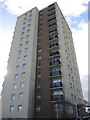
Holroyd House
Dominating the local appearance, the tower is 17 floors high (some 50m, 164') and was built in 1968-9.
Image: © Neil Owen
Taken: 22 Feb 2022
0.07 miles
3
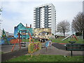
Keeping an eye on the kids
A play area next to the Rising Sun with Polden House in the background.
Image: © Neil Owen
Taken: 21 Apr 2022
0.07 miles
4
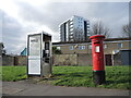
Communicating on Somerset Terrace
A modern phone box (with a phone in it!) and a letterbox on a road that was previously called Windmill Hill Terrace into the early part of the twentieth century. The letterbox is a Georgian variety, made by Carron of Stirlingshire.
Image: © Neil Owen
Taken: 22 Feb 2022
0.07 miles
6
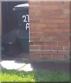
Ordnance Survey Cut Mark
This OS cut mark can be found on No271 St Johns Lane. It marks a point 13.929m above mean sea level.
Image: © Adrian Dust
Taken: 12 Mar 2020
0.09 miles
7

See you at the Rising Sun
In case you can't see properly this is the side of the Rising Sun on Alfred Street. It was created a couple of years ago and replaces an older mural.
Image: © Neil Owen
Taken: 23 Jul 2021
0.09 miles
8
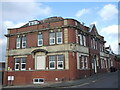
Ordnance Survey Cut Mark
This OS cut mark can be found on The Fox Inn, Somerset Terrace. It marks a point 40.276m above mean sea level.
Image: © Adrian Dust
Taken: 12 Mar 2020
0.09 miles
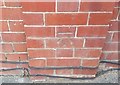
9
An old fox under cover
This building was the Fox Inn on Somerset Terrace, but was converted into flats in 2009. In the past the road was called Windmill Hill Terrace and the pub was a different building; clearly, a new pub was founded next door around the turn of the 1900s but retained the same name and, presumably, landlord. A benchmark can be found on the brickwork facing the road - see Image] - or see Image] for a look at the detailed stonework.
Image: © Neil Owen
Taken: 22 Feb 2022
0.09 miles
10
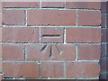
Benchmark on the old Fox Inn
The old pub is now flats but the benchmark remains as part of the fabric. See Image] for a wider view and https://www.bench-marks.org.uk/bm87850 for the entry in the Benchmark Database.
Image: © Neil Owen
Taken: 22 Feb 2022
0.09 miles