IMAGES TAKEN NEAR TO
Mendip Road, BRISTOL, BS3 4PB
Introduction
This page details the photographs taken nearby to Mendip Road, BS3 4PB by members of the Geograph project.
The Geograph project started in 2005 with the aim of publishing, organising and preserving representative images for every square kilometre of Great Britain, Ireland and the Isle of Man.

There are currently over 7.5m images from over14,400 individuals and you can help contribute to the project by visiting https://www.geograph.org.uk
Image Map
Images are licensed for reuse under creativecommons.org/licenses/by-sa/2.0
Notes
- Clicking on the map will re-center to the selected point.
- The higher the marker number, the further away the image location is from the centre of the postcode.
Image Listing (345 Images Found)
Images are licensed for reuse under creativecommons.org/licenses/by-sa/2.0
Image
Details
Distance
1

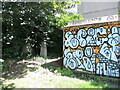
The Windmill Peacock
A piece of suburban art on a residential wall, in a somewhat inconspicuous part of town. It was created in 2012 by artist Andy Council. The homeowner has added some natural colour to the mainly blue palette.
Image: © Neil Owen
Taken: 23 Jul 2021
0.04 miles
2
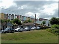
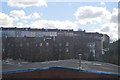
Terraced houses in Bedminster overlooking the Malago Greenway
The river Malago flows to the right of the picture in a channel.
Image: © Anthony O'Neil
Taken: 5 Jul 2010
0.06 miles
3
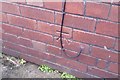
Ordnance Survey Cut Mark
This OS cut mark can be found on No71 Dunkerry Road. It marks a point 28.112m above mean sea level.
Image: © Adrian Dust
Taken: 12 Mar 2020
0.07 miles
5
A few stones are all that are left
This is the top corner of the old St John's cemetery - a broad square of green that has a steep slope from Windmill Hill. The burial grounds have long been disused and are now largely given over to a public open space with lots of trees. However, there are a few memorial stones tucked away next to an electricity substation - which is, naturally, covered in spray.
Image: © Neil Owen
Taken: 23 Jul 2021
0.08 miles
6
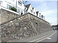
Revetment on Cotswold Road
A large concrete embankment marks a sharp drop in the levels. This part of south Bristol was originally an open space known as Mutton Hill, overlooking a now-lost ore works. Although most of the houses were built in the nineteenth century (in typical terraces) these houses here were a later addition, possibly twentieth century. The revetment may be of that age.
Image: © Neil Owen
Taken: 23 Jul 2021
0.08 miles
7
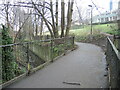
Crossing the Malago
A modern footbridge reaches across the old stream. Previously walkers would have had to make a long trek to cross it. Beyond is the slope of an open green space - that used to be a typical Victorian terrace of houses before demolition.
Image: © Neil Owen
Taken: 18 Jan 2022
0.09 miles
8
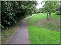
Path through a former burial ground, Bedminster, Bristol
Located near the site of the former St John's Church. This area was an extra burial place used when St John’s churchyard became full. St John's Church was severely damaged by incendiary bombs in November 1940. The church ruins were cleared away in 1967, tombs and headstones were removed and the areas grassed over.
Image: © Jaggery
Taken: 5 Sep 2018
0.10 miles
9

Windmill Hill Bristol
A decorative but rather complicated looking pedestrian crossing at a junction near Windmill Hill.
Image: © Robert Ashby
Taken: 24 Apr 2014
0.10 miles
10
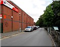
Road past the edge of Malago Vale Trading Estate, Bedminster, Bristol
VP Hire Station https://www.geograph.org.uk/photo/5919763 is on the left.
Image: © Jaggery
Taken: 5 Sep 2018
0.10 miles