IMAGES TAKEN NEAR TO
St. Lukes Road, BRISTOL, BS3 4BH
Introduction
This page details the photographs taken nearby to St. Lukes Road, BS3 4BH by members of the Geograph project.
The Geograph project started in 2005 with the aim of publishing, organising and preserving representative images for every square kilometre of Great Britain, Ireland and the Isle of Man.

There are currently over 7.5m images from over14,400 individuals and you can help contribute to the project by visiting https://www.geograph.org.uk
Image Map
Images are licensed for reuse under creativecommons.org/licenses/by-sa/2.0
Notes
- Clicking on the map will re-center to the selected point.
- The higher the marker number, the further away the image location is from the centre of the postcode.
Image Listing (348 Images Found)
Images are licensed for reuse under creativecommons.org/licenses/by-sa/2.0
Image
Details
Distance
1
Save this view!
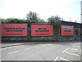
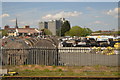
Large posters draw attention to the present landscape and views from Totterdown, views that have pleased people for generations. However, there are many plans being cast about the area to create large blocks, like the ones being built at Totterdown Bridge Image The locals are trying hard to stop their views being ruined and include an image on the posters.
Image: © Neil Owen
Taken: 5 May 2022
0.01 miles
2
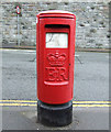
Pillar box on St Luke's Road
A modern E II R box.
Image: © Thomas Nugent
Taken: 16 Aug 2011
0.02 miles
3
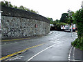
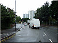
St Luke's Road
The railway line to Temple Meads runs above the retaining wall.
Image: © Thomas Nugent
Taken: 16 Aug 2011
0.03 miles
4
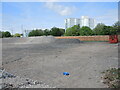
Lost the flavour
The site is cleared now, ready for a new future. Up until last year this was the home of Bart Spices, later Bart Ingredients, a Bristol herbs and spice company, started in 1963 by Jo and Reg Bartlam. Their offerings proved popular and for some time this was their offices. However, they moved out to Severn Beach and the old buildings are gone.
Whilst the future is not yet in reach, this is actually the site of Victorian terraces: Weare Street was deleted from the maps, whereas Mead Street (where the shot was taken from) remains, although full of post-war offices and businesses now.
Image: © Neil Owen
Taken: 5 May 2022
0.04 miles
6
St Luke's Road
Looking towards the Avon and the banana bridge.
Image: © Thomas Nugent
Taken: 16 Aug 2011
0.04 miles
7
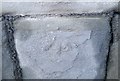
Ordnance Survey Cut Mark
This worn OS cut mark can be found on the wall east side of Luke's Road. It marks a point 10.101m above mean sea level.
Image: © Adrian Dust
Taken: 19 Jan 2020
0.05 miles
8
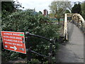
Disabled diversion
Langton Street Bridge (locally referred to as the Banana bridge) is about to be given some attention by engineers. The city council has set aside some funds to repair decay in the bridges that span this stretch of the New Cut. Naturally, the bridges will have to close whilst work is undertaken, meaning every user will have to divert.
Image: © Neil Owen
Taken: 5 May 2022
0.05 miles
9
NEW
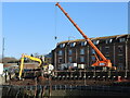
A tricky job on the New Cut
Riverbank collapse had been found and alerted the authorities to the scale. Heavy machinery including a piledriver has been brought to bear.
Image: © Neil Owen
Taken: 12 Mar 2025
0.05 miles
10
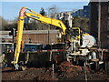
NEW
Pinning the crumbling bank
The New Cut had become unstable and a threat to the road beside it. Heavy machinery has had to get to grips with the damage. A piledriver indicates the significant need for help.
Image: © Neil Owen
Taken: 12 Mar 2025
0.05 miles