IMAGES TAKEN NEAR TO
The Orchard, BRISTOL, BS34 8YT
Introduction
This page details the photographs taken nearby to The Orchard, BS34 8YT by members of the Geograph project.
The Geograph project started in 2005 with the aim of publishing, organising and preserving representative images for every square kilometre of Great Britain, Ireland and the Isle of Man.

There are currently over 7.5m images from over14,400 individuals and you can help contribute to the project by visiting https://www.geograph.org.uk
Image Map
Images are licensed for reuse under creativecommons.org/licenses/by-sa/2.0
Notes
- Clicking on the map will re-center to the selected point.
- The higher the marker number, the further away the image location is from the centre of the postcode.
Image Listing (25 Images Found)
Images are licensed for reuse under creativecommons.org/licenses/by-sa/2.0
Image
Details
Distance
1
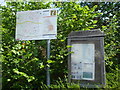
Stoke Gifford notice board
The parish council organ of communication and a handy map.
Image: © Neil Owen
Taken: 25 May 2019
0.10 miles
2
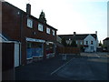
Much the same in 2005 but hardly thriving
Parsons Avenue - corner of North Road, Stoke Gifford, more run down in 2005 than in the 1960's. General store now closed, the shop on left a dog grooming parlour. Newer shopping facilities have opened elsewhere to serve a more densely populated area.
Image: © John Phillips
Taken: 12 Sep 2005
0.13 miles
3
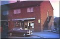
Parson's Ave, Stoke Gifford
Newsagents Shop and Flat over. Council owned property in the mid '60s
Image: © John Lomas
Taken: Unknown
0.13 miles
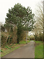
4
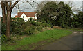
Path, Stoke Gifford
Footpath LSG 7/20 turns right here.
Image: © Derek Harper
Taken: 3 Mar 2020
0.14 miles
5
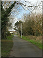
Path, Stoke Gifford
Footpath LSG 7/20 heading towards the bend, to the left in this view, shown in Image
Image: © Derek Harper
Taken: 3 Mar 2020
0.15 miles
6
Path, Stoke Gifford
A reverse view of Image] along footpath LSG 7/20.
Image: © Derek Harper
Taken: 3 Mar 2020
0.15 miles
7
Cul-de-sac, Stoke Gifford
Off Rock Lane, and parallel to Image
Image: © Derek Harper
Taken: 3 Mar 2020
0.15 miles
8
Path, Stoke Gifford
A reverse view of Image], showing footpath LSG 7/20. Just over the hedge on the right is the cul-de-sac shown in Image
Image: © Derek Harper
Taken: 3 Mar 2020
0.15 miles
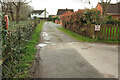
9
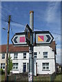
The many coloured ways
A local signpost showing some local cycle routes.
Image: © Neil Owen
Taken: 25 May 2019
0.15 miles
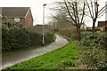
10
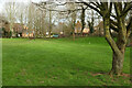
Green space by Newbrick Road
Seen from footpath LSG 7/20. The houses are on Bakers Ground.
Image: © Derek Harper
Taken: 3 Mar 2020
0.15 miles