IMAGES TAKEN NEAR TO
Lysander Walk, BRISTOL, BS34 8XE
Introduction
This page details the photographs taken nearby to Lysander Walk, BS34 8XE by members of the Geograph project.
The Geograph project started in 2005 with the aim of publishing, organising and preserving representative images for every square kilometre of Great Britain, Ireland and the Isle of Man.

There are currently over 7.5m images from over14,400 individuals and you can help contribute to the project by visiting https://www.geograph.org.uk
Image Map (Loading...)


Getting Data...Please wait
Leaflet Map data © OpenStreetMap
Images are licensed for reuse under creativecommons.org/licenses/by-sa/2.0
Notes
- Clicking on the map will re-center to the selected point.
- The higher the marker number, the further away the image location is from the centre of the postcode.
Image Listing (20 Images Found)
Images are licensed for reuse under creativecommons.org/licenses/by-sa/2.0
Image
Details
Distance
1
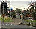
2012 : Mead Road and access path, Great Stoke
Or it might be Stoke Gifford.
A cycleway and footpath crosses the B4057 Winterbourne Road at the traffic lights.
Image: © Maurice Pullin
Taken: 16 Feb 2012
0.14 miles
2
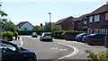
Tyrrel Way, Stoke Gifford, 2
Part of the vast estate of late 20th century housing to the north of Bristol.
Image: © Jonathan Billinger
Taken: 17 Jun 2017
0.15 miles
3
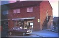
Parson's Ave, Stoke Gifford
Newsagents Shop and Flat over. Council owned property in the mid '60s
Image: © John Lomas
Taken: Unknown
0.15 miles
4
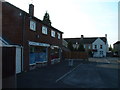
Much the same in 2005 but hardly thriving
Parsons Avenue - corner of North Road, Stoke Gifford, more run down in 2005 than in the 1960's. General store now closed, the shop on left a dog grooming parlour. Newer shopping facilities have opened elsewhere to serve a more densely populated area.
Image: © John Phillips
Taken: 12 Sep 2005
0.15 miles
5
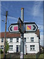
The many coloured ways
A local signpost showing some local cycle routes.
Image: © Neil Owen
Taken: 25 May 2019
0.16 miles
6
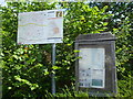
Stoke Gifford notice board
The parish council organ of communication and a handy map.
Image: © Neil Owen
Taken: 25 May 2019
0.17 miles
7

Bee and Lavender
A July morning and the deep blue blooms of Lavandula 'Hidcote' attract the bees.
Image: © Jonathan Billinger
Taken: 9 Jul 2021
0.17 miles
8

Passiflora caerulea
Exotic-looking but hardy in sheltered gardens in UK.
Image: © Jonathan Billinger
Taken: 12 Aug 2017
0.18 miles
9
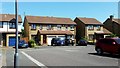
Tyrrel Way, Stoke Gifford, 1
Part of the vast estate of late 20th century housing to the north of Bristol.
Image: © Jonathan Billinger
Taken: 17 Jun 2017
0.18 miles
10
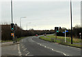
2012 : B4057 Crossing on the road to Winterbourne
Installed to protect motorists crossing this hazardous cycleway and footpath between Watch Elm Close and Mead Road.
Image: © Maurice Pullin
Taken: 16 Feb 2012
0.18 miles