IMAGES TAKEN NEAR TO
Ratcliffe Drive, BRISTOL, BS34 8UD
Introduction
This page details the photographs taken nearby to Ratcliffe Drive, BS34 8UD by members of the Geograph project.
The Geograph project started in 2005 with the aim of publishing, organising and preserving representative images for every square kilometre of Great Britain, Ireland and the Isle of Man.

There are currently over 7.5m images from over14,400 individuals and you can help contribute to the project by visiting https://www.geograph.org.uk
Image Map (Loading...)


Getting Data...Please wait
Leaflet Map data © OpenStreetMap
Images are licensed for reuse under creativecommons.org/licenses/by-sa/2.0
Notes
- Clicking on the map will re-center to the selected point.
- The higher the marker number, the further away the image location is from the centre of the postcode.
Image Listing (17 Images Found)
Images are licensed for reuse under creativecommons.org/licenses/by-sa/2.0
Image
Details
Distance
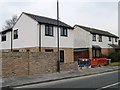
2
Tyrrel Way, Stoke Gifford, 2
Part of the vast estate of late 20th century housing to the north of Bristol.
Image: © Jonathan Billinger
Taken: 17 Jun 2017
0.08 miles
3

Bee and Lavender
A July morning and the deep blue blooms of Lavandula 'Hidcote' attract the bees.
Image: © Jonathan Billinger
Taken: 9 Jul 2021
0.10 miles
4

Passiflora caerulea
Exotic-looking but hardy in sheltered gardens in UK.
Image: © Jonathan Billinger
Taken: 12 Aug 2017
0.10 miles
5
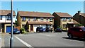
Tyrrel Way, Stoke Gifford, 1
Part of the vast estate of late 20th century housing to the north of Bristol.
Image: © Jonathan Billinger
Taken: 17 Jun 2017
0.11 miles
6
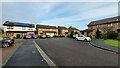
Tyrrel Way
The end of the cul-de-sac on Boxing Day 2021.
Image: © Jonathan Billinger
Taken: 26 Dec 2021
0.12 miles
7
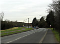
2012 : B4057 Winterbourne Road
Looking west toward Patchway and Filton.
The B4057 is a link road between Winterbourne and the A38 south of Patchway.
Image: © Maurice Pullin
Taken: 16 Feb 2012
0.13 miles
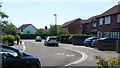
8
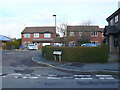
Albany Gate
Albany gate is a small close of houses off Ratcliffe Drive in the heart of residential Stoke Gifford just north of Bristol Parkway station
Image: © Nigel Mykura
Taken: 17 Mar 2013
0.13 miles
10
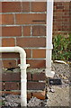
Benchmark on 'Ringbourne', Winterbourne Road
Ordnance Survey cut mark benchmark described on the Bench Mark Database at http://www.bench-marks.org.uk/bm74124
Image: © Roger Templeman
Taken: 12 Mar 2016
0.16 miles