IMAGES TAKEN NEAR TO
Pilkington Close, BRISTOL, BS34 8JU
Introduction
This page details the photographs taken nearby to Pilkington Close, BS34 8JU by members of the Geograph project.
The Geograph project started in 2005 with the aim of publishing, organising and preserving representative images for every square kilometre of Great Britain, Ireland and the Isle of Man.

There are currently over 7.5m images from over14,400 individuals and you can help contribute to the project by visiting https://www.geograph.org.uk
Image Map (Loading...)


Getting Data...Please wait
Leaflet Map data © OpenStreetMap
Images are licensed for reuse under creativecommons.org/licenses/by-sa/2.0
Notes
- Clicking on the map will re-center to the selected point.
- The higher the marker number, the further away the image location is from the centre of the postcode.
Image Listing (104 Images Found)
Images are licensed for reuse under creativecommons.org/licenses/by-sa/2.0
Image
Details
Distance
1
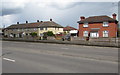
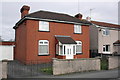
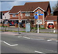
Station Road houses, Filton
On the north side of the A4174 Station Road.
The left edge of the row of houses is on the corner of Pilkington Close.
Image: © Jaggery
Taken: 27 Apr 2016
0.04 miles
2
The Sidings, Filton
On the north side of the A4174 Station Road, in 2016 The Sidings is a residential cul-de-sac. This was formerly the access road to Filton Junction station which closed in March 1996. Services were transferred to the new Filton Abbey Wood station, about 500 metres away.
Image: © Jaggery
Taken: 27 Apr 2016
0.05 miles
3
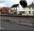
Abbeywood Tots, Filton
Children's day nursery at 97 Station Road, Filton.
Image: © Jaggery
Taken: 27 Apr 2016
0.05 miles
4
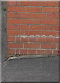
Benchmark on #113 Station Road
Ordnance Survey cut mark benchmark described on the Bench Mark Database at http://www.bench-marks.org.uk/bm47483
Image: © Roger Templeman
Taken: 2 Mar 2013
0.05 miles
5
#113 Station Road
There is an OS benchmark Image on the front of the house near the left hand corner
Image: © Roger Templeman
Taken: 2 Mar 2013
0.05 miles
6
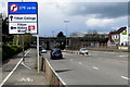
Station Road directions sign, Filton
Facing westbound traffic on the A4174 Station Road.
The white markings behind the sign draw attention to the lamppost on the cycle lane.
Image: © Jaggery
Taken: 27 Apr 2016
0.07 miles
7
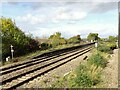
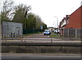
Filton Junction railway station (site), Gloucestershire
Opened in 1903 by the Great Western Railway on the line from Bristol to the Severn Tunnel, this station replaced the first Filton station immediately south of here. In turn, this station closed in 1997 and was replaced by Filton Abbey Wood station, some 400m behind the camera position.
View north from a passing train heading for Bristol Parkway. The two lines to the left head for the Severn Tunnel. Some platforms were still extant when this image was taken but the buildings had all been demolished.
Image: © Nigel Thompson
Taken: 12 Oct 2017
0.07 miles
8
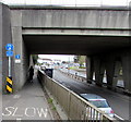
Cyclists give way to pedestrians sign, Filton
The separate pavement and cycle lane above the A4174 Station Road merge under this http://www.geograph.org.uk/photo/4955099 railway bridge.
Image: © Jaggery
Taken: 27 Apr 2016
0.08 miles
9
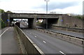
Railway bridge over Station Road, Filton
The bridge carries four railway tracks over the A4174 Station Road 500 metres north of Filton Abbey Wood station.
Image: © Jaggery
Taken: 27 Apr 2016
0.08 miles
10
Cycle routes signpost, Station Road, Filton
Four blue arms show various cycle route destinations and their distances.
Image: © Jaggery
Taken: 27 Apr 2016
0.08 miles