IMAGES TAKEN NEAR TO
Conygre Grove, BRISTOL, BS34 7HX
Introduction
This page details the photographs taken nearby to Conygre Grove, BS34 7HX by members of the Geograph project.
The Geograph project started in 2005 with the aim of publishing, organising and preserving representative images for every square kilometre of Great Britain, Ireland and the Isle of Man.

There are currently over 7.5m images from over14,400 individuals and you can help contribute to the project by visiting https://www.geograph.org.uk
Image Map
Images are licensed for reuse under creativecommons.org/licenses/by-sa/2.0
Notes
- Clicking on the map will re-center to the selected point.
- The higher the marker number, the further away the image location is from the centre of the postcode.
Image Listing (36 Images Found)
Images are licensed for reuse under creativecommons.org/licenses/by-sa/2.0
Image
Details
Distance
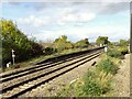
1
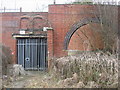
Former Filton Railway Station
A prominent landmark in North Bristol is the clover leaf interchange of four railway lines, previously sporting four railway stations, now partly disused.
Image: © Dr Duncan Pepper
Taken: 9 Mar 2010
0.07 miles
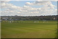
2
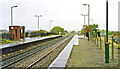
Filton (Junction) station, 1992
View northward: ex-GWR from Bristol, towards Avonmouth via Henbury (to left), Severn Tunnel and South Wales (in centre); to right Bristol Parkway, Swindon etc. and London, also Cheltenham and Birmingham via Yate. This is a grim relic of a station which was replaced later (11/3/96) by a new station at Filton Abbey Wood, ¼-mile to the south. Local trains on the line to Swindon had ceased since 11/9/61 and those to Avonmouth since 23/11/64.
Image: © Ben Brooksbank
Taken: 25 Oct 1992
0.09 miles
3
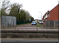
The Sidings, Filton
On the north side of the A4174 Station Road, in 2016 The Sidings is a residential cul-de-sac. This was formerly the access road to Filton Junction station which closed in March 1996. Services were transferred to the new Filton Abbey Wood station, about 500 metres away.
Image: © Jaggery
Taken: 27 Apr 2016
0.14 miles
4
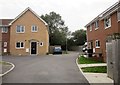
Stuart MacCullum Close, Filton
The 1:25000 map clearly shows a way through here to Ventnor Road, but if there was one there isn't one any longer.
Image: © Derek Harper
Taken: 29 Sep 2014
0.15 miles
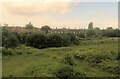
5
Filton Junction railway station (site), Gloucestershire
Opened in 1903 by the Great Western Railway on the line from Bristol to the Severn Tunnel, this station replaced the first Filton station immediately south of here. In turn, this station closed in 1997 and was replaced by Filton Abbey Wood station, some 400m behind the camera position.
View north from a passing train heading for Bristol Parkway. The two lines to the left head for the Severn Tunnel. Some platforms were still extant when this image was taken but the buildings had all been demolished.
Image: © Nigel Thompson
Taken: 12 Oct 2017
0.15 miles
7
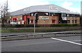
Howdens Joinery, Filton
Viewed across Station Road. The business's website states "Howdens Joinery is the UK's leading manufacturer and supplier of fitted kitchens, appliances and joinery products."
Image: © Jaggery
Taken: 27 Apr 2016
0.18 miles
9
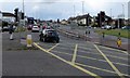
Station Road pelican crossing, Filton
Across the A4174 opposite the Filton Avenue junction.
Chambers Dictionary states that "pelican" is adapted from "pedestrian light controlled crossing".
Image: © Jaggery
Taken: 27 Apr 2016
0.18 miles
10
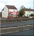
Abbeywood Tots Day Nursery, Filton
Located at 97 Station Road, adjacent to a railway bridge. http://www.geograph.org.uk/photo/2147755
The nursery is registered for 32 children from 0 - 5 years of age.
Image: © Jaggery
Taken: 6 Nov 2010
0.19 miles