IMAGES TAKEN NEAR TO
Boverton Road, BRISTOL, BS34 7AH
Introduction
This page details the photographs taken nearby to Boverton Road, BS34 7AH by members of the Geograph project.
The Geograph project started in 2005 with the aim of publishing, organising and preserving representative images for every square kilometre of Great Britain, Ireland and the Isle of Man.

There are currently over 7.5m images from over14,400 individuals and you can help contribute to the project by visiting https://www.geograph.org.uk
Image Map (Loading...)


Getting Data...Please wait
Leaflet Map data © OpenStreetMap
Images are licensed for reuse under creativecommons.org/licenses/by-sa/2.0
Notes
- Clicking on the map will re-center to the selected point.
- The higher the marker number, the further away the image location is from the centre of the postcode.
Image Listing (16 Images Found)
Images are licensed for reuse under creativecommons.org/licenses/by-sa/2.0
Image
Details
Distance
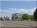
1
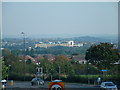
Filton - Looking towards AXA Insurance Building
Taken from the foot bridge over Station Road Filton.
Image: © John Phillips
Taken: 10 Oct 2005
0.03 miles
2
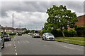
Filton : Filton Avenue
Looking along Filton Avenue.
Image: © Lewis Clarke
Taken: 11 Jul 2023
0.08 miles
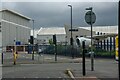
3
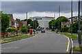
Filton : Filton Avenue
Looking along the road with the Airbus site in the background.
Image: © Lewis Clarke
Taken: 11 Jul 2023
0.08 miles
4

Filton : Filton Avenue - Ravens
Two ravens having a pigeon for lunch.
Image: © Lewis Clarke
Taken: 11 Jul 2023
0.09 miles
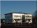
6
Filton College
On the A38 heading towards Almondsbury.
Image: © Steve Fareham
Taken: 3 Jun 2010
0.15 miles
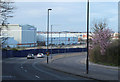
7
Filton : Gloucester Road North A38
At the road junction opposite the Airbus site.
Image: © Lewis Clarke
Taken: 11 Jul 2023
0.16 miles
8
2011 : A38 passing the Airbus works at Filton
Image: © Maurice Pullin
Taken: 20 Mar 2011
0.20 miles
10
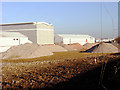
Rubble - was once the Rodney Works, Patchway
The old industrial buildings have now been demolished and turned into different coloured piles of rubble.
Detailed historic maps and photographs of Filton area can be found at:
http://www.aviationarchive.org.uk/map/index.php
including an aerial photo of the Rodney Works.
Image: © Linda Bailey
Taken: 26 Jan 2006
0.22 miles