IMAGES TAKEN NEAR TO
Glebelands Road, BRISTOL, BS34 7AE
Introduction
This page details the photographs taken nearby to Glebelands Road, BS34 7AE by members of the Geograph project.
The Geograph project started in 2005 with the aim of publishing, organising and preserving representative images for every square kilometre of Great Britain, Ireland and the Isle of Man.

There are currently over 7.5m images from over14,400 individuals and you can help contribute to the project by visiting https://www.geograph.org.uk
Image Map (Loading...)


Getting Data...Please wait
Leaflet Map data © OpenStreetMap
Images are licensed for reuse under creativecommons.org/licenses/by-sa/2.0
Notes
- Clicking on the map will re-center to the selected point.
- The higher the marker number, the further away the image location is from the centre of the postcode.
Image Listing (25 Images Found)
Images are licensed for reuse under creativecommons.org/licenses/by-sa/2.0
Image
Details
Distance
1
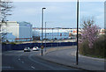
2011 : A38 passing the Airbus works at Filton
Image: © Maurice Pullin
Taken: 20 Mar 2011
0.07 miles
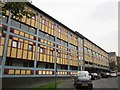
2
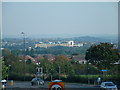
Filton - Looking towards AXA Insurance Building
Taken from the foot bridge over Station Road Filton.
Image: © John Phillips
Taken: 10 Oct 2005
0.11 miles
3
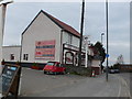
The Horseshoe
Presumably this was once a pub. It has now reinvented itself as a bed and breakfast establishment. It is on the A38 dual carriageway Gloucester Road North opposite Station Rd. I don't know what kind of B&B it is but it is right next door to a licensed sex shop called My Only Vice
Image: © Nigel Mykura
Taken: 23 Feb 2013
0.14 miles
4
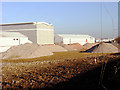
Rubble - was once the Rodney Works, Patchway
The old industrial buildings have now been demolished and turned into different coloured piles of rubble.
Detailed historic maps and photographs of Filton area can be found at:
http://www.aviationarchive.org.uk/map/index.php
including an aerial photo of the Rodney Works.
Image: © Linda Bailey
Taken: 26 Jan 2006
0.14 miles
5
Church View, Filton
Flats (and shops, including a post office) that look across Church Road to St Peter's church.
Image: © Derek Harper
Taken: 29 Sep 2014
0.15 miles
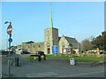
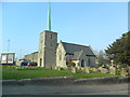
8
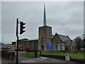
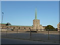
St Peter's Church, Filton
Built in 1844 to replace a medieval church, it was extended in 1960/61 and the needle spire erected.
Image: © Eirian Evans
Taken: 29 Jan 2016
0.15 miles
10
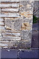
Benchmark on St Peter's Church
Ordnance Survey 1GL bolt benchmark described on the Bench Mark Database at http://www.bench-marks.org.uk/bm28931
Image: © Roger Templeman
Taken: 2 Mar 2013
0.16 miles