IMAGES TAKEN NEAR TO
Gipsy Patch Lane, BRISTOL, BS34 6QD
Introduction
This page details the photographs taken nearby to Gipsy Patch Lane, BS34 6QD by members of the Geograph project.
The Geograph project started in 2005 with the aim of publishing, organising and preserving representative images for every square kilometre of Great Britain, Ireland and the Isle of Man.

There are currently over 7.5m images from over14,400 individuals and you can help contribute to the project by visiting https://www.geograph.org.uk
Image Map (Loading...)


Getting Data...Please wait
Leaflet Map data © OpenStreetMap
Images are licensed for reuse under creativecommons.org/licenses/by-sa/2.0
Notes
- Clicking on the map will re-center to the selected point.
- The higher the marker number, the further away the image location is from the centre of the postcode.
Image Listing (65 Images Found)
Images are licensed for reuse under creativecommons.org/licenses/by-sa/2.0
Image
Details
Distance
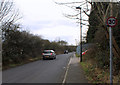
1
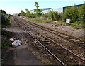
Towards Patchway Junction from Patchway railway station
Looking south from platform 1. The shape of Patchway Junction resembles a diamond on a playing card.
At the junction are lines south to Filton Abbey Wood station and SE to Bristol Parkway station.
Image: © Jaggery
Taken: 13 May 2015
0.02 miles
2
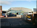
SGB Vehicle Services, Little Stoke
Located in Pegasus Park, Gipsy Patch Lane, adjacent to the railway bridge. http://www.geograph.org.uk/photo/2156291
Image: © Jaggery
Taken: 6 Nov 2010
0.03 miles
3
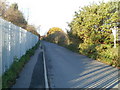
Station Road, Little Stoke
Station Road heads north away from Gipsy Patch Lane towards Patchway railway station, about 300 metres away.
Image: © Jaggery
Taken: 6 Nov 2010
0.03 miles
4
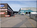
Patchway, Pegasus Park
Industrial estate on Gipsy Patch Lane.
Image: © Mike Faherty
Taken: 29 Mar 2014
0.04 miles
5
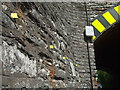
Reflective tags for demolition reference
This old railway bridge is due to be substantially widened and some laser survey markers have been placed in the stonework.
Image: © Neil Owen
Taken: 30 May 2019
0.06 miles
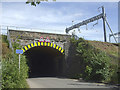
6
Patchway, railway bridge
Carrying the South Wales Main Line over Gipsy Patch Lane.
Image: © Mike Faherty
Taken: 29 Mar 2014
0.06 miles
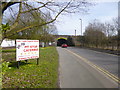
7
Gypsy Patch Lane Railway Bridge
The railway bridge is being replaced as part of a Metrobus extension. Gypsy Patch Lane has been closed temporarily for traffic, but it is still possible to get through as a pedestrian. Social distancing on this path is a challenge. You are asked to wait here until the route is clear but you can't actually see the whole route under the bridge.
Image: © Bill Boaden
Taken: 10 Jul 2020
0.06 miles
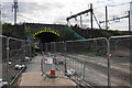
8
Gypsy Path Lane railway bridge
Earmarked for demolition, bringing traffic woes for all those who use it whilst the replacement is built.
Image: © Neil Owen
Taken: 30 May 2019
0.06 miles
9
2012 : Station Road, Patchway, Bristol
Looking south toward Gipsy Patch Lane.
Patchway Railway Station is to the north, a few hundred yards behind the camera position.
Image: © Maurice Pullin
Taken: 16 Feb 2012
0.07 miles
10
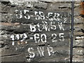
Gypsy Patch Lane railway bridge sign
A typical bridge mark, but one that is a collector's item. In a few months time it will be no more.
Image: © Neil Owen
Taken: 30 May 2019
0.07 miles