IMAGES TAKEN NEAR TO
Orion Drive, BRISTOL, BS34 6JB
Introduction
This page details the photographs taken nearby to Orion Drive, BS34 6JB by members of the Geograph project.
The Geograph project started in 2005 with the aim of publishing, organising and preserving representative images for every square kilometre of Great Britain, Ireland and the Isle of Man.

There are currently over 7.5m images from over14,400 individuals and you can help contribute to the project by visiting https://www.geograph.org.uk
Image Map (Loading...)


Getting Data...Please wait
Leaflet Map data © OpenStreetMap
Images are licensed for reuse under creativecommons.org/licenses/by-sa/2.0
Notes
- Clicking on the map will re-center to the selected point.
- The higher the marker number, the further away the image location is from the centre of the postcode.
Image Listing (11 Images Found)
Images are licensed for reuse under creativecommons.org/licenses/by-sa/2.0
Image
Details
Distance
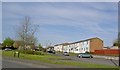
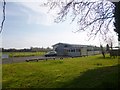
1
Little Stoke Primary School
On Little Stoke Lane: http://www.littlestokeps.co.uk/
Image: © Mike Faherty
Taken: 29 Mar 2014
0.06 miles
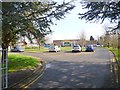
4
Little Stoke Youth Centre
On Little Stoke Lane: http://www.stokegifford.org.uk/index.php/news-and-events/208-transformation-review-programme-integrated-services-for-young-people
Image: © Mike Faherty
Taken: 29 Mar 2014
0.13 miles
5
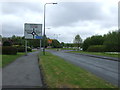
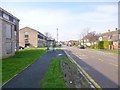
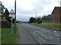
Hatchet Road heading south
Towards Stoke Gifford.
Image: © JThomas
Taken: 11 May 2013
0.14 miles