IMAGES TAKEN NEAR TO
Titan Road, BRISTOL, BS34 6FD
Introduction
This page details the photographs taken nearby to Titan Road, BS34 6FD by members of the Geograph project.
The Geograph project started in 2005 with the aim of publishing, organising and preserving representative images for every square kilometre of Great Britain, Ireland and the Isle of Man.

There are currently over 7.5m images from over14,400 individuals and you can help contribute to the project by visiting https://www.geograph.org.uk
Image Map (Loading...)


Getting Data...Please wait
Leaflet Map data © OpenStreetMap
Images are licensed for reuse under creativecommons.org/licenses/by-sa/2.0
Notes
- Clicking on the map will re-center to the selected point.
- The higher the marker number, the further away the image location is from the centre of the postcode.
Image Listing (36 Images Found)
Images are licensed for reuse under creativecommons.org/licenses/by-sa/2.0
Image
Details
Distance
1
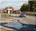
Gipsy Patch Lane reaches Little Stoke
The view east along Gipsy Patch Lane. Little Stoke, in the parish of Stoke Gifford, is in South Gloucestershire, though it is sometimes stated to be a suburb of north Bristol.
Image: © Jaggery
Taken: 6 Nov 2010
0.04 miles
2

Development land in Horizon 38
A vacant site in a new business park.
Image: © Bill Boaden
Taken: 10 Jul 2020
0.12 miles
3

Filton : Titan Road
Looking along Titan Road.
Image: © Lewis Clarke
Taken: 11 Jul 2023
0.13 miles
4

Filton : Bolingbroke Way
Looking across the roundabout.
Image: © Lewis Clarke
Taken: 11 Jul 2023
0.14 miles
5

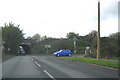
Diversion at roundabout on Bolingbroke Way
Horizon 38 Business Park; Titan Road comes in from the left.
Image: © M J Roscoe
Taken: 24 Aug 2022
0.14 miles
6

Filton : Belvedere Close
Looking towards Ceva on Belvedere Close.
Image: © Lewis Clarke
Taken: 11 Jul 2023
0.15 miles
7

Filton : Bolingbroke Way
Looking along Bolingbroke Way.
Image: © Lewis Clarke
Taken: 11 Jul 2023
0.15 miles
8

Patchway, Pegasus Park
Industrial estate on Gipsy Patch Lane.
Image: © Mike Faherty
Taken: 29 Mar 2014
0.16 miles
9
Gipsy Patch Lane
Looking west along Gipsy Patch lane to the narrow arch bridge carrying the main rail line to South Wales. The road at right is Station Road which, as its name implies, provides access to Patchway station.
Image: © Phil Williams
Taken: 24 Nov 2005
0.16 miles
10
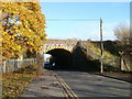
Gipsy Patch Lane railway bridge, Little Stoke
Two triangular warning signs are side by side at the top of the bridge arch. One shows the height as 13 feet 3 inches, the other shows 4 metres. Patchway railway station, on the route to the Severn Tunnel and South Wales, is about 300 metres to the north (left) of the bridge. Station Road is on the far side of the bridge.
Image: © Jaggery
Taken: 6 Nov 2010
0.16 miles