IMAGES TAKEN NEAR TO
Stoke Lane, BRISTOL, BS34 6DY
Introduction
This page details the photographs taken nearby to Stoke Lane, BS34 6DY by members of the Geograph project.
The Geograph project started in 2005 with the aim of publishing, organising and preserving representative images for every square kilometre of Great Britain, Ireland and the Isle of Man.

There are currently over 7.5m images from over14,400 individuals and you can help contribute to the project by visiting https://www.geograph.org.uk
Image Map (Loading...)


Getting Data...Please wait
Leaflet Map data © OpenStreetMap
Images are licensed for reuse under creativecommons.org/licenses/by-sa/2.0
Notes
- Clicking on the map will re-center to the selected point.
- The higher the marker number, the further away the image location is from the centre of the postcode.
Image Listing (8 Images Found)
Images are licensed for reuse under creativecommons.org/licenses/by-sa/2.0
Image
Details
Distance
2
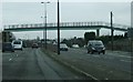
Askew footbridge
This footbridge across the A38 in Patchway is distinctive because it crosses the road at an acute angle rather than at 90 degrees. The eastern set of steps run almost parallel to the carriageway, whilst the western ones are at roughly right angles to the road.
Image: © Ruth Riddle
Taken: 6 Jan 2012
0.19 miles
3
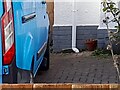
Ordnance Survey Cut Mark
This OS cut mark can be found on No165 Gloucester Road. It marks a point 65.697m above mean sea level.
Image: © Adrian Dust
Taken: 24 Dec 2022
0.22 miles
6
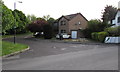
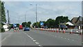
The Sherrings, Patchway
Cul-de-sac on the north side of Brookfield Road.
Image: © Jaggery
Taken: 13 May 2015
0.23 miles
7
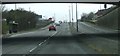
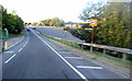
The A38 passing under the B4057
The overbridge where the B4057 joins the A38 casts a shadow onto the main road. The bus stop pictured is to the south of this, so even when the sun is low, people waiting there will not be in the shade of the roadway above.
Image: © Ruth Riddle
Taken: 6 Jan 2012
0.24 miles
8
Brookfield Road Pumping Station, Patchway
Wessex Water site.
Image: © Jaggery
Taken: 13 May 2015
0.25 miles