IMAGES TAKEN NEAR TO
Standish Avenue, BRISTOL, BS34 6AJ
Introduction
This page details the photographs taken nearby to Standish Avenue, BS34 6AJ by members of the Geograph project.
The Geograph project started in 2005 with the aim of publishing, organising and preserving representative images for every square kilometre of Great Britain, Ireland and the Isle of Man.

There are currently over 7.5m images from over14,400 individuals and you can help contribute to the project by visiting https://www.geograph.org.uk
Image Map (Loading...)


Getting Data...Please wait
Leaflet Map data © OpenStreetMap
Images are licensed for reuse under creativecommons.org/licenses/by-sa/2.0
Notes
- Clicking on the map will re-center to the selected point.
- The higher the marker number, the further away the image location is from the centre of the postcode.
Image Listing (5 Images Found)
Images are licensed for reuse under creativecommons.org/licenses/by-sa/2.0
Image
Details
Distance
3
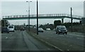
Askew footbridge
This footbridge across the A38 in Patchway is distinctive because it crosses the road at an acute angle rather than at 90 degrees. The eastern set of steps run almost parallel to the carriageway, whilst the western ones are at roughly right angles to the road.
Image: © Ruth Riddle
Taken: 6 Jan 2012
0.17 miles
5
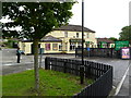
Patchway, Travellers Rest
A sprawling two-roomed pub on Gloucester Road, with videos, games machines and pool. Cask ales on offer at my visit: Greene King IPA, Hardy & Hanson Bitter, Morland Old Speckled Hen. For some customer comments, see http://www.beerintheevening.com/pubs/s/24/24498/Travellers_Rest/Patchway
Image: © Mike Faherty
Taken: 20 Jul 2011
0.24 miles