IMAGES TAKEN NEAR TO
Callicroft Road, BRISTOL, BS34 5BU
Introduction
This page details the photographs taken nearby to Callicroft Road, BS34 5BU by members of the Geograph project.
The Geograph project started in 2005 with the aim of publishing, organising and preserving representative images for every square kilometre of Great Britain, Ireland and the Isle of Man.

There are currently over 7.5m images from over14,400 individuals and you can help contribute to the project by visiting https://www.geograph.org.uk
Image Map
Images are licensed for reuse under creativecommons.org/licenses/by-sa/2.0
Notes
- Clicking on the map will re-center to the selected point.
- The higher the marker number, the further away the image location is from the centre of the postcode.
Image Listing (27 Images Found)
Images are licensed for reuse under creativecommons.org/licenses/by-sa/2.0
Image
Details
Distance
1
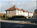
Callicroft Road, Patchway
Houses at the SE end of Callicroft Road. The turning on the left is Hazeldene Road. Callicroft Road runs along the NE perimeter of Filton Airfield.
Image: © Jaggery
Taken: 6 Nov 2010
0.11 miles
4
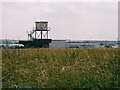
Observation Tower on Filton Airfield
In the background is Image seen from the opposite side of the airfield.
Image: © Linda Bailey
Taken: 29 Jun 2006
0.13 miles
5
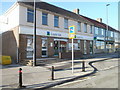
Lloyds TSB Patchway
Bank branch at 61 Gloucester Road.
Image: © Jaggery
Taken: 6 Nov 2010
0.16 miles
6
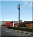
Mobile phone mast next to Patchway Fire Station
Located on Durban Road, adjacent to Patchway Fire Station. http://www.geograph.org.uk/photo/2155614
The mast is 15 metres high (about 49 feet).
Image: © Jaggery
Taken: 6 Nov 2010
0.16 miles
7
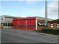
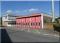
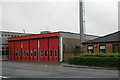
Patchway Fire Station
Avon Fire & Rescue fire station, viewed along Durban Road. The station offices, and main entrance, are around the corner in Rodway Road. The station is equipped with two 1800 litre water tenders (usually called fire engines by the public) and one Ariel platform. The locations covered by the station include Cribbs Causeway Mall (indoor shopping centre), Filton Airfield, Airbus UK and Rolls Royce.
The metal structure on the right is a 15-metre high mobile phone mast. http://www.geograph.org.uk/photo/2155598
Image: © Jaggery
Taken: 6 Nov 2010
0.16 miles
8

Camera on Gloucester Road
Monitoring traffic on the A38 heading towards Bristol.
Image: © Bill Boaden
Taken: 10 Jul 2020
0.16 miles
9
Patchway Fire Station
Patchway Fire Station, Rodway Road, Patchway, Bristol is station number 04 of Avon Fire & Rescue Service
Image: © Kevin Hale
Taken: 8 May 2006
0.17 miles