IMAGES TAKEN NEAR TO
Gloucester Road, BRISTOL, BS34 5BQ
Introduction
This page details the photographs taken nearby to Gloucester Road, BS34 5BQ by members of the Geograph project.
The Geograph project started in 2005 with the aim of publishing, organising and preserving representative images for every square kilometre of Great Britain, Ireland and the Isle of Man.

There are currently over 7.5m images from over14,400 individuals and you can help contribute to the project by visiting https://www.geograph.org.uk
Image Map
Images are licensed for reuse under creativecommons.org/licenses/by-sa/2.0
Notes
- Clicking on the map will re-center to the selected point.
- The higher the marker number, the further away the image location is from the centre of the postcode.
Image Listing (53 Images Found)
Images are licensed for reuse under creativecommons.org/licenses/by-sa/2.0
Image
Details
Distance
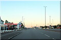
1

Camera on Gloucester Road
Monitoring traffic on the A38 heading towards Bristol.
Image: © Bill Boaden
Taken: 10 Jul 2020
0.07 miles
2
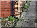
Ordnance Survey Cut Mark
This OS cut mark can be found on the old hall east side of the Gloucester Road. It marks a point 65.252m above mean sea level.
Image: © Adrian Dust
Taken: 24 Dec 2022
0.07 miles
3
The A38 south passing the Esso Rontec garage
Image: © Roy Hughes
Taken: 9 Jul 2022
0.10 miles
4
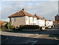
Callicroft Road, Patchway
Houses at the SE end of Callicroft Road. The turning on the left is Hazeldene Road. Callicroft Road runs along the NE perimeter of Filton Airfield.
Image: © Jaggery
Taken: 6 Nov 2010
0.14 miles
5
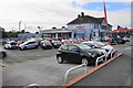
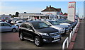
Car dealership at Patchway
The building must have been formerly a pub.
Image: © Bill Boaden
Taken: 10 Jul 2020
0.15 miles
6
Motorline Toyota Bristol North, Patchway
Car dealership alongside the A38 Gloucester Road, Patchway.
Image: © Jaggery
Taken: 13 May 2015
0.15 miles
7
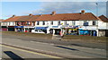
Gloucester Road shops, Patchway
Located opposite Callicroft Road. Among the premises are a branch of Barclays Bank
and a Stroud & Swindon Building Society office.
Image: © Jaggery
Taken: 6 Nov 2010
0.15 miles
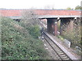
8
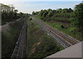
High level and low level lines towards Patchway railway station
Viewed from the A38 Gloucester Road. A cutting and an embankment are side by side. The line on the left was the original single-track line to Patchway railway station which opened nearby in 1863.
After the Severn Tunnel opened in 1886, so many trains brought coal from South Wales that the second track on the right had to be built. The new track was at a different level, so the station had to be moved further south to its present site out of shot ahead, where the lines are at the same level.
Image: © Jaggery
Taken: 13 May 2015
0.17 miles
9
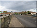
A38 at Patchway
looking north along the A38 at patchway, north Bristol. The road crosses the main rail line to south Wales between the photographers position and the overbridge.
Image: © Phil Williams
Taken: 24 Nov 2005
0.17 miles
10
Rails to South Wales
Looking west to the brick bridge carrying traffic over the main rail line to South Wales. Note the different levels of the tracks at this point.
Image: © Phil Williams
Taken: 24 Nov 2005
0.17 miles