1
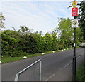
Patchway 1st railway station (site), Gloucestershire
Opened in 1863 by the Bristol & South Wales Union Railway, later part of the Great Western Railway, on the line from Bristol to New Passage (for ferry connections across the Bristol Channel). This station closed in 1885 when it was replaced by the current Patchway station. The line was diverted (and lowered here) into the new Severn Tunnel which opened in 1886, rendering the New Passage branch redundant.
View south east towards the replacement Patchway (out of sight around the curve) and Bristol. The first station was in the middle distance and was two parallel platforms, although the line to New Passage was just single track.
Image: © Nigel Thompson
Taken: 9 Oct 2021
0.06 miles
2
Car dealership at Patchway
The building must have been formerly a pub.
Image: © Bill Boaden
Taken: 10 Jul 2020
0.06 miles
3
Motorline Toyota Bristol North, Patchway
Car dealership alongside the A38 Gloucester Road, Patchway.
Image: © Jaggery
Taken: 13 May 2015
0.06 miles
4
The A38 south passing the Esso Rontec garage
Image: © Roy Hughes
Taken: 9 Jul 2022
0.06 miles
5
Ordnance Survey Cut Mark
This OS cut mark can be found on the old hall east side of the Gloucester Road. It marks a point 65.252m above mean sea level.
Image: © Adrian Dust
Taken: 24 Dec 2022
0.07 miles
6
Warning sign - school nearby, Station Road, Little Stoke
A path from Station Road ahead leads to a primary school.
Image: © Jaggery
Taken: 13 May 2015
0.07 miles
7
Three notices on a Station Road lamppost, Little Stoke
In descending order are a CCTV camera notice, a Fly Tipping - See it Report It! notice
and a This is a Neighbourhood Watch Area notice.
Image: © Jaggery
Taken: 13 May 2015
0.07 miles
8
White painted rocks at the edge of Station Road, Little Stoke
Preventing vehicles parking on the grass.
Image: © Jaggery
Taken: 13 May 2015
0.07 miles
9
High level and low level lines towards Patchway railway station
Viewed from the A38 Gloucester Road. A cutting and an embankment are side by side. The line on the left was the original single-track line to Patchway railway station which opened nearby in 1863.
After the Severn Tunnel opened in 1886, so many trains brought coal from South Wales that the second track on the right had to be built. The new track was at a different level, so the station had to be moved further south to its present site out of shot ahead, where the lines are at the same level.
Image: © Jaggery
Taken: 13 May 2015
0.07 miles
10
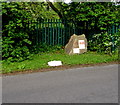
Station Road boulder marking the original location of Patchway railway station
An information board on the boulder records that the railway came to Patchway in 1863 as a single track line as far as Pilning. Patchway Station was just here. There was a weighbridge by the station to check that wagons were not overladen. The tall houses in Station Road were built for railway officials such as the station master.
After the Severn Tunnel opened in 1886, so many trains brought coal from South Wales that a second track had to be built. The new track was at a different level http://www.geograph.org.uk/photo/4474548 so the station had to be moved further south to its present site, about 750 metres away (and further away from Patchway), where the lines are at the same level.
Image: © Jaggery
Taken: 13 May 2015
0.07 miles


