IMAGES TAKEN NEAR TO
Bartletts Road, BRISTOL, BS3 3PL
Introduction
This page details the photographs taken nearby to Bartletts Road, BS3 3PL by members of the Geograph project.
The Geograph project started in 2005 with the aim of publishing, organising and preserving representative images for every square kilometre of Great Britain, Ireland and the Isle of Man.

There are currently over 7.5m images from over14,400 individuals and you can help contribute to the project by visiting https://www.geograph.org.uk
Image Map
Images are licensed for reuse under creativecommons.org/licenses/by-sa/2.0
Notes
- Clicking on the map will re-center to the selected point.
- The higher the marker number, the further away the image location is from the centre of the postcode.
Image Listing (199 Images Found)
Images are licensed for reuse under creativecommons.org/licenses/by-sa/2.0
Image
Details
Distance
1
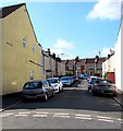
Beaufort Street, Bedminster, Bristol
From Stanley Street South along Beaufort Street towards Bartlett's Road.
Image: © Jaggery
Taken: 5 Sep 2018
0.01 miles
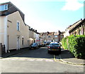
2
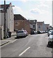
Bartlett's Road, Bedminster, Bristol
On the SE side of the A38 West Street. The gap in the cars on the left is at the Buckingham Street junction.
Image: © Jaggery
Taken: 5 Sep 2018
0.03 miles
3
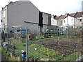
A gap for a market garden
A gap in the houses on Stanley Terrace were originally homes, but they were demolished some time after WWII. In their place the land is turned over to growing vegetables.
Image: © Neil Owen
Taken: 17 Feb 2022
0.03 miles
4
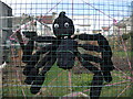
A spider on Stanley Terrace
A small open patch is used as an allotment, with some rather charming inhabitants.
Image: © Neil Owen
Taken: 17 Feb 2022
0.04 miles
5
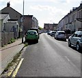
Buckingham Street, Bedminster, Bristol
From Stanley Street South along Buckingham Street towards Bartlett's Road.
Image: © Jaggery
Taken: 5 Sep 2018
0.04 miles
6
From Bartlett's Road to Bartlett's Bridge
A view of some of south Bristol from the road as it drops to the railway bridge. It is now shorter than it used to be.
Image: © Neil Owen
Taken: 17 Feb 2022
0.04 miles
7
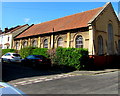
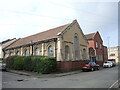
United Reformed Church, Bedminster, Bristol
This is the southeast side of the church, on the corner of Buckingham Street and South Stanley Street.
Image: © Jaggery
Taken: 5 Sep 2018
0.05 miles
8
Churchlands Road, Bedminster, Bristol
From West Street along Churchlands Road towards Brighton Terrace.
The green car is near the entrance to South Bristol Christian Centre. https://www.geograph.org.uk/photo/5921744
Image: © Jaggery
Taken: 5 Sep 2018
0.05 miles
9
West Street United Reformed Church
Although the order was founded in the seventeenth century, it was not until the twentieth century that this plot on West Street was used. The brick building marks it as a modern structure but the more traditional building is of the same age.
Image: © Neil Owen
Taken: 17 Feb 2022
0.06 miles
10
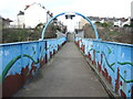
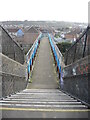
Bartlett's Bridge
The footbridge over the G.W.R. lines is actually older than the houses that lie to the south by quite some time. The area north seen here is a mid nineteenth century development, whereas the south side is interwar.
Image: © Neil Owen
Taken: 17 Feb 2022
0.06 miles