IMAGES TAKEN NEAR TO
Westbourne Grove, BRISTOL, BS3 3LJ
Introduction
This page details the photographs taken nearby to Westbourne Grove, BS3 3LJ by members of the Geograph project.
The Geograph project started in 2005 with the aim of publishing, organising and preserving representative images for every square kilometre of Great Britain, Ireland and the Isle of Man.

There are currently over 7.5m images from over14,400 individuals and you can help contribute to the project by visiting https://www.geograph.org.uk
Image Map
Images are licensed for reuse under creativecommons.org/licenses/by-sa/2.0
Notes
- Clicking on the map will re-center to the selected point.
- The higher the marker number, the further away the image location is from the centre of the postcode.
Image Listing (539 Images Found)
Images are licensed for reuse under creativecommons.org/licenses/by-sa/2.0
Image
Details
Distance
1
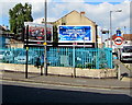
Two Primesight advertising boards on a Bedminster corner, Bristol
Set back from West Street on the corner of Diamond Street.
Image: © Jaggery
Taken: 5 Sep 2018
0.01 miles
2
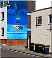
Shades of blue and turquoise on a Westbourne Grove wall, Bedminster, Bristol
Mural in the background here. https://www.geograph.org.uk/photo/5895830
Image: © Jaggery
Taken: 5 Sep 2018
0.02 miles
3
Vacant West Street shop to be auctioned, Bedminster, Bristol
In September 2018 an Auction board is on the unnamed shop at the NE end of West Street.
An August 2017 Google Earth Street View show Miller's Organic Hair & Beauty shop here.
Image: © Jaggery
Taken: 5 Sep 2018
0.02 miles
4
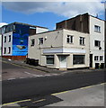
Unnamed shop on a Bedminster corner, Bristol
On the corner of Westbourne Grove (left side) and the A38 West Street.
Image: © Jaggery
Taken: 5 Sep 2018
0.02 miles
5
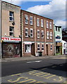
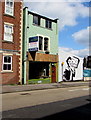
Peter's Barbers in Bedminster, Bristol
Viewed across the A38 West Street.
Image: © Jaggery
Taken: 5 Sep 2018
0.02 miles
6
Rosemont Villa, British Road
Rosemont Villa was built around 1900. It is first shown on the 1898-1939 OS 25" 3rd Edition.
Image: © s
Taken: 13 Aug 2021
0.03 miles
7
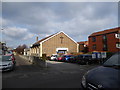
Bedminster Methodist Church, British Road
A modern church replacing a neo-classical church which stood on this site and was demolished in 1980.
Image: © Eirian Evans
Taken: 22 Feb 2018
0.03 miles
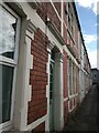
8
Diamond Street, Bedminster, Bristol
One-way street extending from the A38 West Street to British Road.
Image: © Jaggery
Taken: 5 Sep 2018
0.03 miles
9
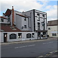
Black Cat, 26 West Street, Bedminster, Bristol
The pub on the corner of Westbourne Grove has a distinctive tall thin chimney stack on the West Street side.
https://www.geograph.org.uk/photo/5895802 to the name sign on the right.
Image: © Jaggery
Taken: 5 Sep 2018
0.03 miles
10
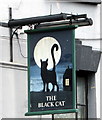
Black Cat pub name sign, 26 West Street, Bedminster, Bristol
Hanging from a wall bracket on the right here. https://www.geograph.org.uk/photo/5895797
Image: © Jaggery
Taken: 5 Sep 2018
0.03 miles