IMAGES TAKEN NEAR TO
Palmyra Road, BRISTOL, BS3 3JY
Introduction
This page details the photographs taken nearby to Palmyra Road, BS3 3JY by members of the Geograph project.
The Geograph project started in 2005 with the aim of publishing, organising and preserving representative images for every square kilometre of Great Britain, Ireland and the Isle of Man.

There are currently over 7.5m images from over14,400 individuals and you can help contribute to the project by visiting https://www.geograph.org.uk
Image Map
Images are licensed for reuse under creativecommons.org/licenses/by-sa/2.0
Notes
- Clicking on the map will re-center to the selected point.
- The higher the marker number, the further away the image location is from the centre of the postcode.
Image Listing (176 Images Found)
Images are licensed for reuse under creativecommons.org/licenses/by-sa/2.0
Image
Details
Distance
1
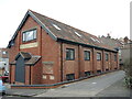
The old Bedminster Tabernacle Hall
The hall was founded in 1927 and was used for worship until 1985. Thereafter it became a small business office until being sold off for development. In 2018 permission was granted to convert it into flats, but having gained it the developers added more flats to the original designs, much to the upset of the locals already here.
Image: © Neil Owen
Taken: 17 Feb 2022
0.01 miles
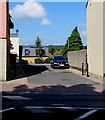
2
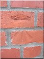
Ordnance Survey Cut Mark
This OS cut mark can be found on the wall on Palmyra Rd, 1.2m from the junction with Elmdale Rd. It marks a point 14.198m above mean sea level.
Image: © Adrian Dust
Taken: 8 Aug 2013
0.02 miles
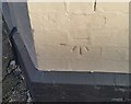
3
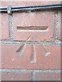
Ordnance Survey Cut Mark
This OS cut mark can be found on No21 Elmdale Rd. It marks a point 20.539m above mean sea level.
Image: © Adrian Dust
Taken: 8 Aug 2013
0.05 miles
4
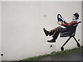
Popping down Palmyra Road
A new artwork has appeared at the top of the road - which is quite steep at this point.
Image: © Neil Owen
Taken: 17 Feb 2022
0.05 miles
5
Kingdom View, Bedminster, Bristol
Cul-de-sac on the NW side of the A38 West Street.
Image: © Jaggery
Taken: 5 Sep 2018
0.07 miles
6
Ordnance Survey Cut Mark
This OS cut mark can be found on the Luckwell Hotel. It marks a point 36.09m above mean sea level.
Image: © Adrian Dust
Taken: 18 Jan 2020
0.08 miles
7
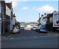
Palmyra Road, Bedminster, Bristol
The SE end of Palmyra Road viewed across the A38 West Street.
Image: © Jaggery
Taken: 5 Sep 2018
0.08 miles
8
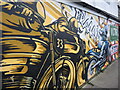
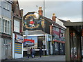
Power in Palmyra Road
A motorcycle garage has a big and bold mural to advertise it.
Image: © Neil Owen
Taken: 17 Feb 2022
0.08 miles
9
Artwork on The Three Lions BS3
As might be guessed from the artwork this pub has a clientele that revolves around Bristol City FC.
Image: © Steve Barnes
Taken: 5 Nov 2016
0.08 miles
10
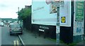
Junction of Palmyra Road and West Street
Image: © Clint Mann
Taken: 3 Sep 2015
0.08 miles